PLANTS | ANIMALS | ECOLOGY | FUNGI | GEOLOGY | GARDENING | TOOLS
MEXICAN PLANTS & ANIMALS HOME

Excerpts from Jim Conrad's
Naturalist Newsletter
from the February 6, 2012 Newsletter issued from Hacienda Chichen Resort beside Chichén Itzá Ruins; limestone bedrock; elevation ~39m (~128ft), N20.675°, W88.569°; central Yucatán state, MÉXICO
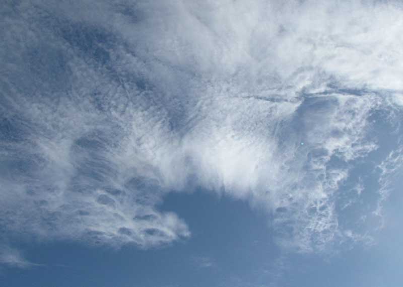
CIRROCUMULUS LACUNOSUS CLOUDS
On most days here for the last couple of weeks we've been receiving showers and sometimes even good rains, which is very unusual for this time of year. When our landscape should be crispy dry with drought and the color of cured hay, it's greening as if it were the rainy season, which shouldn't begin until late May or so. Also, Sara on the coast writes of unusually large amounts of Sargasso seaweed piling up on beaches.
Therefore, I wasn't surprised the other day to see a cloud formation I've rarely noticed, the one at the top of this page. The top of the picture is occupied with fairly normal altostratus/altocumulus formations, but at the bottom such honeycombed parts are seldom seen.
Especially at the lower left the clouds' wispy streaking denotes high clouds containing ice crystals, thus classifying them as cirrus. In general each cloud body is somewhat puffy, of the cumulus type, so you put the two types together and you get cirrocumulus. The World Meteorological Organization says that when cirrocumulus clouds are pockmarked with large, clear holes you have a special variety of cloud -- not a species in this case -- known as CIRROCUMULUS LACUNOSUS, "lacunae" being a technical term for cavities, holes or gaps in something.
These clouds developed in advance of a rain-bringing warm front arriving from the southeast.