PLANTS | ANIMALS | ECOLOGY | FUNGI | GEOLOGY | GARDENING | TOOLS
MEXICAN PLANTS & ANIMALS HOME

Excerpts from Jim Conrad's
Naturalist Newsletter
entry dated January 1, 2023, issued from near Tequisquiapan, elevation about 1,900m (6200 ft), ~N20.57°, ~ W99.89°, Querétaro state, MÉXICO
A PILEUS CLOUD
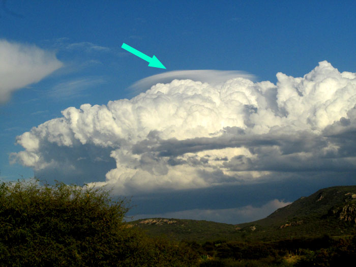
In late afternoon the storm clouds shown above built toward the east, forming above the foothills of the Eastern Sierra Madre mountain chain. The upward-billowing cloud mass was dark at the bottom, a classic developing thunderstorm. Such cumulonimbus clouds had been forming there for several days in a row, but their rain never reached our area, where it was so badly needed.
The interesting feature about these particular thunderheads was that above the storm's upward-developing "cloud tower," a separate more diffuse cloud with a smooth, gently curved top -- shaped almost like an upside-down saucer -- was formed, indicated above by the blue arrow.
This kind of cloud, appearing above developing cloud towers of cumulus and cumulonimbus clouds, is thought of as a kind of "cloud accessory," not a cloud that forms by itself. Usually it's referred to as a PILEUS CLOUD, though sometimes it's called a cap cloud.
Pileus cloud formations develop when air associated with a cumulus or cumulonimbus cloud tower rises so fast that humidity in the air cools and condenses into the pileus cloud. Forming so high up, pileus clouds are composed of ice crystals. Pileus clouds are somewhat uncommon, and they don't last long. The pileus in the above picture isn't nearly as impressively shaped as it was before I took 30 seconds to snatch the camera and shoot. In 30 more seconds it mostly had dissipated.
A rare and much-sought form of pileus cloud may be seen when sunlight hits the cloud just right, and becomes brilliant with rainbow-colored iridescence, when sunlight bounces off the ice crystals.