
PLANTS | ANIMALS | ECOLOGY | FUNGI | GEOLOGY | GARDENING | TOOLS
Excerpts from Jim Conrad's
Naturalist Newsletter
from the April 29, 2012 Newsletter issued from the woods of the Loess Hill Region a few miles east of Natchez, Mississippi, USA
LOESS ROADCUTS
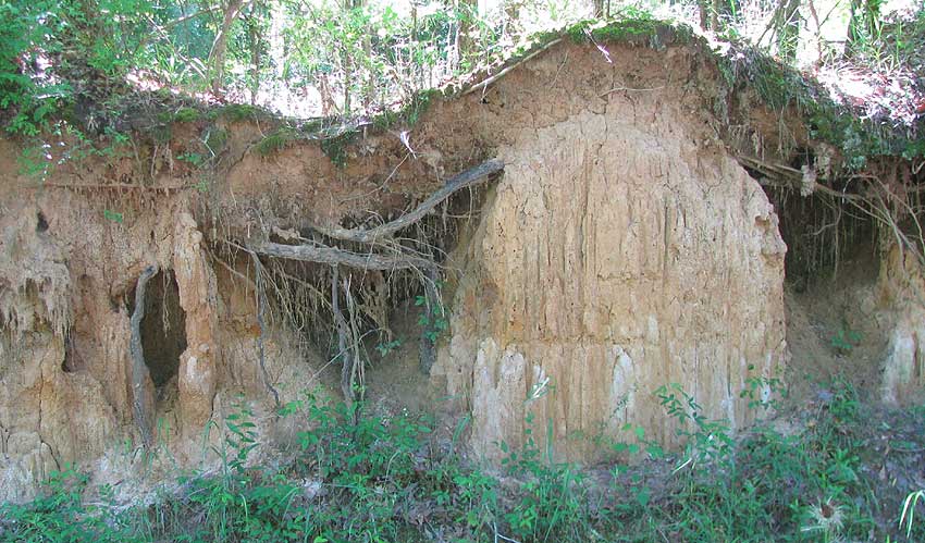
As I wander the countryside on my old bike, one of the most eye-catching features of the landscape is what's shown above.
That's a roadcut through a special kind of very fine-grained clay called loess. The word loess derives from the German Löß. A deep mantel of loess was deposited here at the end of the last Ice Age about 10,000 years ago. Deep loess deposits occur in a narrow band of upland immediately east of the Mississippi River over most of its entire course. The loess region sometimes is called the Loess Hills. Loess profoundly affects the area's ecology. For one thing, the farther east you go from the Mississippi River, the thinner the loess is, the poorer and more acidic the soil becomes, and the more pines you get instead of broadleaf deciduous trees.
Loess is so important here, and so interesting, that years ago I developed a web portal called "Loess Hills of the Lower Mississippi Valley," at https://www.backyardnature.net/loess/index.htm.
I had hoped to engage local folks in an effort to recognize the Loess Hills as a very interesting, scenic and biologically important, distinct region with ecotourism potential, but nothing ever came from it. At that site you can learn how "loess" can be pronounced, how it came to exist here, what's special about it, and much more.
One thing special about loess is that it erodes into vertical-sided roadcuts as in the picture. People such as road engineers who try to create gentle slopes are doomed to failure. I wish my farming Maya friends in the Yucatan, who must deal with very thin, rocky soil, could see the thick mantel of rich loess we have here.
from the May 13, 2012 Newsletter issued from the woods of the Loess Hill Region a few miles east of Natchez, Mississippi, USA
LOESS EROSION
Loess erodes in a manner different from that of regular dirt. It exhibits what's known as a "high angle of repose." That means that where loess is unprotected by vegetation it erodes cavities with near-vertical walls. Thing is, nowadays highway engineers and builders on loess soil appear to have forgotten this fact. Again and again around here you see attempts to landscape loess into long slopes that are eye-pleasing until the first rain, when frightful erosion results as the loess begins its process of developing vertical walls. In the old days, highway engineers dealing with deep roadcuts through loess created steps or terraces with vertical walls. It looked funny, but it didn't collapse or erode much. Nowadays engineers and landscapers are back to gentle slopes and they're causing outrageous erosion and stream clogging.
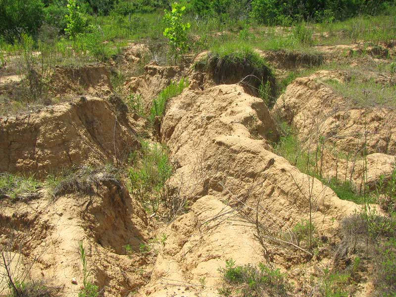
When I was last here in 2009 a landowner built himself a lake by bulldozing up a high levee of loess across a narrow valley. The levee's walls sloped on both sides. I've been waiting to see what happened. This week I biked out to take a look.
The lake was empty except for mud in the bottom. You can see the state of the levee dam below:
A gentle slope from the woods down to the lake had become what's shown below:
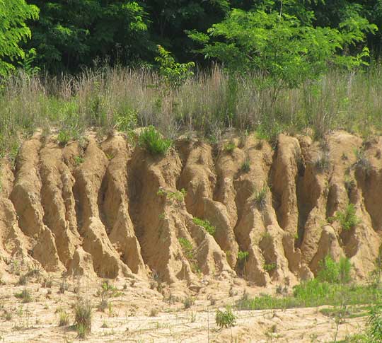
Fifty years ago no one would have made such a mess. It was common knowledge then that loess erodes like this, and that certain measures can to be taken to accommodate the loess's natural disposition. But now that knowledge is either forgotten, or else now a lot of people are stupefied by the belief that money trumps natural laws. I do believe that this wrecked lake gives us a glance into the near future when education will be much less available to the masses, and the small numbers of rich and powerful will be even more rich and powerful, and stupefied, and therefore even more destructive.
from the May 19, 2002 Newsletter issued from the woods of the Loess Hill Region a few miles south of Natchez, Mississippi; elevation ~200ft (~60m), ~N31.42°, ~W91.41°; USA
LOESS FOSSILS
A while back Lonnie Looper in Greenville, Mississippi contacted me asking if I wanted to place pictures of fossils he had collected, at my Loess-Zone Web site.
For some years Lonnie and his wife Freida have collected over 500 fossil bones of Ice Age animals which lived in our loess area between 10,000 and 250,000 years ago. These are not entire skeletons, just a vertebrate here, a horn there, which the couple found while walking on gravel bars in the Mississippi River during low-water times. Among the species represented are Giant Ground Sloth, Llama, Mammoth, Mastodon, Musk Ox, Stag Moose and Tapir.
A number of fossil horse teeth also have been found. Horses were actually native to North America, but they went extinct, possibly because of overhunting by early humans. All the horses in America today were reintroduced here from the Old World.
You can see some of these fossils here.
from the May 19, 2002 Newsletter issued from the woods of the Loess Hill Region a few miles south of Natchez, Mississippi; elevation ~200ft (~60m), ~N31.42°, ~W91.41°; USA
LOESS BLUES
The other day Leon up near Vicksburg, where loess lies 200 feet deep (60 m) and more, wrote describing problems he was having. He lives at the base of a terraced loess cliff. The terraces are now becoming honeycombed with tunnels, and he's nervous because he knows that disturbed loess, when wet, turns to water-gravy.
It was hard to find anything encouraging to say to Leon. As long as our loess lies just as it was deposited 10 to 12 ago, it's pretty stable stuff. However, if an armadillo digs a hole in a loess bank, before long that hole becomes a gully. If a tree root grows through the loess, when the tree dies and the root disintegrates, water begins trickling along the channel left by the root, and before long you have a gully. In fact, just about any disturbance in loess inexorably leads to a gully that inexorably grows and grows.
In the old days people understood and respected this feature of loess. Road engineers made road cuts through loess with vertical walls, leaving alleys that remained stable and picturesque for decades. Nowadays trees are cut way back from roads, and road cuts are provided with broad, shallowly sloping sides. Nothing could be more inviting to erosion. If you travel this area, just look at the outrageous gullies forming in those wide, new road cuts, even before the road- department's grass seed germinate. And wherever there's a loess bluff at the edge of town, look how people are cutting back forest and building expensive houses right at the edges of those bluffs.
By the way, the pronunciation of "loess" is such a contentious matter that I provide a special page on the subject at www.backyardnature.net/loess/pronounc.htm. I pronounce it more or less like "lerss," but with a special curl in my tongue I could never accomplish without having spent a goodly part of my life trying to pronounce the German "ö".
from the March 16, 2003 Newsletter issued from the woods of the Loess Hill Region a few miles south of Natchez, Mississippi; elevation ~200ft (~60m), ~N31.42°, ~W91.41°; USA
LOESS RAVINES & WARREN GRABAU'S BEAVER DAMS
Ever since I have been here I have wondered about something regarding the loess mantling the entire plantation at depths of maybe 30 to 50 feet (9 to 15 m). That is, gullying in this loess goes on at an astonishing rate. Right now a ravine is eating beneath the fence of one of my gardens and in other places similar ravines are cutting through the woods and into the fields.
On my page at www.backyardnature.net/loess/l_time.htm I explain that our loess was deposited 10 to 12 thousand years ago. Well, if the rate of erosion we see today had been proceeding for at least 10,000 years, it's hard to imagine how there could be any loess uplands left at all. This is where Warren Grabau's beaver dams come in.
Wildlife photographer Jerry Litton and I are involved in a project for which we've been in contact with Mr. Grabau, a geographer in his 80s in Vicksburg, and the author of the excellent Civil War book Ninety-eight Days: A Geographer's View of the Vicksburg Campaign, Univ. of Tenn. Press, Knoxville. 2000. Mr. Grabau has supplied us with some of his essays, and one of them addresses the loess mystery I've just described. I don't know if the material has been published.
Mr. Grabau suggests that during most of the millennia since the loess was deposited, beaver dams may have converted the Loess Zone's waterways into a series of placid dammed pools, and these pools kept erosion in the zone at a minimum. If this is true, the deep, steep-walled ravines that characterize the zone now may be fairly recent phenomena. Our zone, which stretches along the Mississippi's eastern shore from central Louisiana to western Kentucky and beyond, for most of its existence may have been a gently rolling, unbroken upland. This all may have changed when the Europeans began arriving en masse in the early 1700s, with their insatiable appetite for beaver pelts.
Beaver populations were exterminated. Dams washed out. And then the gullying we see today began.
As you wander our loess uplands, you often notice that in places the slopes leading into bayou bottoms are not continuous, but rather broken into a series of terraces. Might not each terrace represent the destruction of yet another major beaver colony?