
PLANTS | ANIMALS | ECOLOGY | FUNGI | GEOLOGY | GARDENING | TOOLS
Excerpts from Jim Conrad's
Naturalist Newsletter
from the February 24, 2013 Newsletter issued from the valley of the Dry Frio River in northern Uvalde County, southwestern Texas, on the southern border of the Edwards Plateau; elevation ~1750m (~5750 ft); N29.62°, W99.86°; USA
GLEN ROSE FORMATION
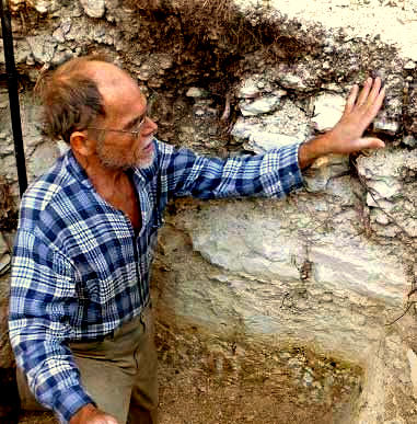
Each day I do enough physical labor to keep my body exercised and my hands callused. During recent weeks I've been digging trenches and pits with pick, shovel and iron bar for a building. Recently I've been excavating a cesspit. That's me standing in my masterpiece at the top.
Digging that pit exposed interesting insights into the location's geology.
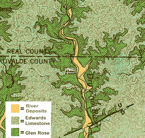
First of all, I knew that I was digging into the geological unit known as the Glen Rose Formation, thanks the Geologic Atlas of Texas, San Antonio sheet - 1982, freely accessible online -- along with hundreds of other such publications covering all of the US -- from the US Geological Survey at http://ngmdb.usgs.gov/Prodesc/proddesc_19384.htm.
Below you see a portion of a map available on the above page showing my digging location -- designated by the greenhouse icon in the center of the page -- in the Glen Rose:
Knowing what formation I was working in, I could look up "Glen Rose Formation" on the Internet, where I learned that I was digging through material deposited 108-113 millions of years ago, during the Early Cretaceous when dinosaurs roamed the area. Glen Rose material consists mostly of various forms of limestone, but also there are layers of quartz siltstone, sandstone, marl, dolomite and other rock types. There's more about the Glen Rose Formation than a person can digest at https://ngmdb.usgs.gov/Prodesc/proddesc_19384.htm.
In the cesspit, the deeper you go, the older the rocks become. That's just how sedimentary geology works, with newer material being piled atop older. Sometimes faulting and other violent forces flips rock strata upside-down or shoves younger rocks below older ones, but that hasn't happened in our area.
Mostly from fossil findings, Glen Rose strata are known to have been deposited in a "transitional marine" environment -- the zone between open ocean and shore. Consequently, digging through the Glen Rose you pass through material ranging from that deposited in deep ocean water, to beach sand in which dinosaur footprints might be found.
In the picture of me in the cesspit, in the bottom of the pit the brownish stratum with white splotches is sand in which white balls of clay are suspended. Sand normally gathers in beach and shallow water environments where relatively strong water currents can carry the sand there, and clay usually settles in quiet waters such as in lake bottoms, so somehow material from two distinct sources was mingled and deposited by floodwaters. Various scenarios enabling such a layer can be imagined. Conceivably a hurricane or tsunami ripped away not only a sandy beach but also the clay platform it lay upon, mingled the contents, and dumped them where I'm standing, though that spot would have been underwater then.
Above the sand with white mudballs you see a layer of solid, white limestone, suggesting that after sand and mudballs were deposited, for a long time the area where I'm standing was under deep ocean water where fine-textured mud settled to the ocean bottom eventually to lithify into the limestone. Such mud very largely consists of microscopic organisms encased in calcium-rich shells.
This long period of mud accumulation eventually was interrupted by some kind of catastrophic event powerful enough to mingle fairly large broken fragments of shattered limestone rock with silt to form the layer even with my shoulders in the picture. That layer looks like the contents of a landslide and one can only imagine what event put such a shattered mix of rocks and silt there.
Above the jumble of large rocks and silt there's the typical dark soil our woods and prairies root in, the results of mere centuries, not millions of years, of complex soil chemistry and biology.
Really, there in the cesspit looking at the geological profile around me, I felt as if I were in a museum where only the most majestic of the Earth's activities are referenced.
from the December 30, 2012 Newsletter issued from the valley of the Dry Frio River in northern Uvalde County, southwestern Texas, on the southern border of the Edwards Plateau; elevation ~1750m (~5750 ft); N29.62°, W99.86°; USA
DIGGING THROUGH THE CRETACEOUS
My house-painting job finished, now I'm digging trenches on the nearby rocky hillside. I like this work, at least for the couple of hours each day I do it.
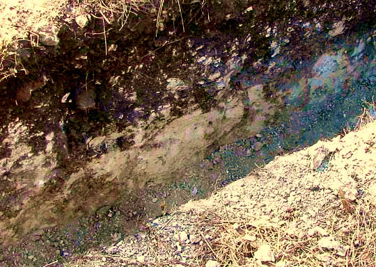
Digging through the soil is easy, but the limestone rock and bedrock below the soil is a challenge. It's not as impossible as it sounds, though, because the limestone varies from crystalline, "rock hard" rock to fairly soft, crumbly stuff. Below you can see one of my trenches with dark soil above transitioning to soft, white limestone below:
The hill's bedrock is mostly Cretaceous limestone, which means that it was deposited as sediment during the Cretaceous geological period between approximately 145.5 and 65.5 million years ago. During the Cretaceous the Earth's sea level was much higher than now. In North America we have extensive outcroppings of Cretaceous-age rocks because during the Cretaceous Period a great sea connected the Arctic Ocean with the Gulf of Mexico, running right through the middle of the continent. The mud in that great sea eventually lithified into limestone and was raised to form much of North America's current interior landscape.
In the above picture, I could dig through that limestone with a shovel. You can see a small rock shoveled from the trench below:
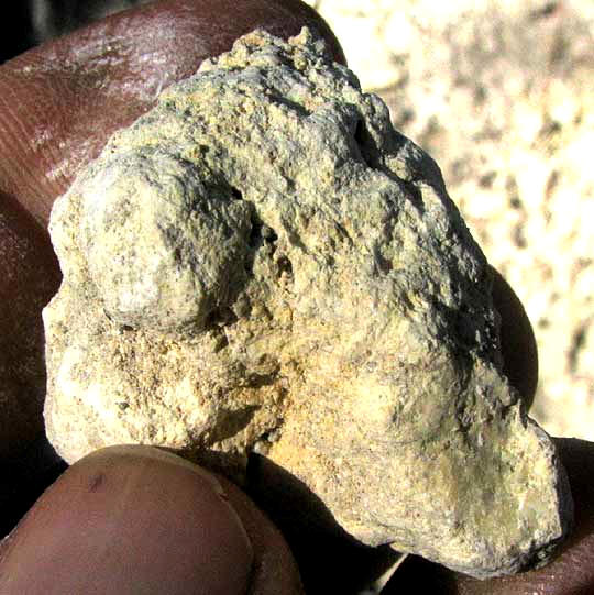
Since solid, crystalline limestone would break forming flat surfaces and sharp edges, you can tell from that rock's rounded, broken surfaces and the powder on my fingers that it is crumbly, porous and lightweight. While digging through it I asked myself if it might be impure chalk. After all, the word Cretaceous is derived from the Latin word for chalk, which is creta, because in many places across the globe besides North America there are many outcroppings of chalk. The "White Cliffs of Dover" in England are white because they are Cretaceous chalk. The Champagne region of France is mostly underlain by Cretaceous chalk into which artificial caves have been dug and used for wine storage. So, why couldn't I be digging through real chalk on our Texas hillside?
The USGS now provides a wonderful Internet page where for free you can access hundreds if not thousands of geological maps covering the entire United States. The page is at http://ngmdb.usgs.gov/maps/MapView/.
There the Geologic atlas of Texas, San Antonio sheet published in 1982 by VE Barnes et al by the University of Texas at Austin informs me that our hills here in northern Uvalde County along the Dry Frio River are capped with the geological unit known as the Edwards Limestone, but on the hills' lower slopes -- where I'm trenching -- the outcropping rocks belong to the Glen Rose Formation.
As with plants and animals, once you have the name of something, you can look it up. Looking up "Glen Rose Formation" on the Internet I find a fine website on Texas fossils with a whole page about the Glen Rose Formation and its fossils, at http://northtexasfossils.com/glenrose.htm.
There I learn that the Glen Rose Formation is composed of rocks from the early part of the Cretaceous Period -- that they're ±108 to ±113 million years old. Also I read that though the Glen Rose Formation is normally thought of as a limestone outcrop, it also contains strata of sandy mudstone, wackestones, calcarenites, marls, micritic limestones, dolomites, quartz siltstones, sandstones, and boundstones. I've never heard of a couple of these terms. Chalk isn't on the list.
Chalk is described as mainly soft, white, very fine-grained, extremely pure, organic limestone composed of shells of microscopic organisms. The rock I'm digging through is not pure and not very fine-grained, so it must not be chalk.
A friend tells me that I'm digging into caliche, which is a kind of rock-hard hardpan that forms in arid and semi-arid lands just below the soil. Calcium carbonate cements together gravel, sand, clay, and silt to form it. However, farther up the slope I'd first encountered the white layer shown in the picture immediately beneath a layer of hard, limestone bedrock, which disappeared as I worked down the slope, so what's in the picture is a Cretaceous-age stratum, not recently formed caliche.
In the list of Glen Rose rock-types, marl catches the eye. Marl is a calcium carbonate or lime-rich mud or mudstone which contains variable amounts of clays and silt. Some people say that "marl" is a too general and imprecise term and that rock called marl more correctly should be called earthy or impure argillaceous limestone. "Argillaceous" is a term describing rocks in which clay minerals are a secondary but significant component. "Clay minerals" are mostly silica based. They're hydrous aluminium phyllosilicates, sometimes with variable amounts of iron, magnesium, alkali metals, and other such non-organic compounds.
So, letting all that digest awhile, I figure that nowadays when I dig down through the soil, if I hit white, soft, impure not-quite-rock that's not caliche, I'm digging into "impure argillaceous limestone," and if I can't remember the word "argillaceous," I'll just call it marl.