
PLANTS | ANIMALS | ECOLOGY | FUNGI | GEOLOGY | GARDENING | TOOLS
Excerpts from Jim Conrad's
Naturalist Newsletter
from the November 18, 2012 Newsletter issued from the valley of the Dry Frio River in northern Uvalde County, southwestern Texas, on the southern border of the Edwards Plateau; elevation ~1750m (~5750 ft); N29.62°, W99.86°; USA
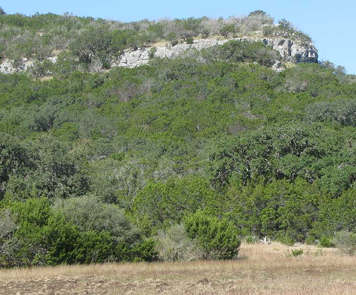
EDWARDS PLATEAU: GEOLOGY NOTES The valley of the little Dry Frio River in which I live runs northward, cutting into the Edwards Plateau. As you travel up the valley, often you see massive white limestone outcrops at the tops of hills, as shown above.
The hill isn't as high as it might seem, because vegetation covering it is low and scrubby. If a person were standing at the cliff's edge you'd see that the cliff is only about 150 feet (45m) above the valley floor.
One reason that limestone-capped hills interest me is that back in geology class I was taught that in the humid eastern US normally hills are capped with sandstone, but in the arid West, often it's limestone. That's because rainfall is slightly acidic and over time dissolves limestone, which is calcium carbonate, a mineral of which one property is that it dissolves in acid. Since hills in general are capped with erosion-resistant rock, the East's water-weakened limestone in not nearly as resistant as sandstone, so a normal Eastern hill, if capped by anything, is capped with sandstone. But out here where rainfall hasn't decayed the limestone to the extent it has in the East, it's pretty hard rock, and it caps lots of hills, like the one in the picture, and like many places in arid northern Mexico.
Another reason this outcropping limestone is interesting is that here we're at the southern boundary of the Edwards Plateau, and the Edwards Plateau is known to be mostly composed of limestone of Cretaceous age. The limestone outcropping in our picture is that limestone. Geologists have figured out that it was deposited at the bottom of a vast inland sea that during Cretaceous times, about 70 million years ago, cut across present-day Texas and much of central North America. At that time dinosaurs ruled the Earth, but you won't find dinosaur footprints in our hilltop limestone because the stone was deposited in the bottom of that sea, where dinosaurs didn't roam. "Forces from within the Earth" have lifted the former ocean floor to where it is atop our hills today.
Also I've been fascinated by the jumbles of loose material exposed in cliff faces at the edges of our little Dry Frio, which is eroding its valley into the Edwards Plateau, as shown below:
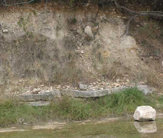
In that picture, it's easy to walk up to the cliff face and with your fingers dislodge any of the cobbles you see protruding the face, which is composed of sand, silt and other loose material. The size of the cobbles shows that the water that left them there was running very fast. And look at that rock "floor" just above the grass at the river's edge. That's shale rock. It's weak shale, easy to scrape apart with a knife, but not soft enough to call mudstone.
That jumble of sand, cobbles and boulders looks as if it were deposited fairly recently -- maybe only a few thousand years ago. And, maybe it was. Maybe the Dry Frio eroded the valley down through the Edwards Plateau's limestone to that bed of shale, then partially filled the valley back up with sand, cobbles and boulders, and now is cutting back into its former depositions.
But, that bed of shale hasn't been deposited there recently. I'm sure of that not only because of logic but because of what I found while studying thebed this week. You can see my discovery below:
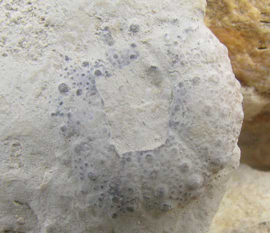
That's a globe-shaped fossil I pried from the shale with my fingernails. It's about half an inch across (12mm) and looks very much like the sea urchin shells found so often along the beach down in the Yucatan.
Best I can tell with my little Golden Nature Guide to Fossils, it's the genus CIDARIS, sometimes known as the pencil sea urchins. The genus arose well before the Cretaceous, and continues living in the world's shallow marine environments. The interesting word in that description of Cidaris is "marine." Like the limestone capping our hills, this bed of shale was deposited in the ocean back in Cretaceous times, when dinosaurs roamed the Earth.
*****
THE EDWARDS PLATEAU ON GOOGLE EARTH
The Edwards Plateau is the southernmost extension of North America's Great Plains. If you've been across North America's Great Plains you know that it amounts to very much flat, somewhat elevated land. Physiographically, the Edwards Plateau is distinguished from the rest of the Great Plains precisely because it is not almost entirely flat upland. The Edwards Plateau is hilly. It's hilly because the entire plateau is tilted enough for water to rush off it, eroding as it goes, forming hills and valleys. The northern and western parts of the Edwards Plateau can range from being somewhat flat to undulating, but here on the southern (and eastern) boundaries the topography is rugged, consisting of canyons separated by flat or undulating divides. These much-dissected southern and eastern parts are known as the Texas Hill Country. I've prepared a Google Earth view to orient us below.
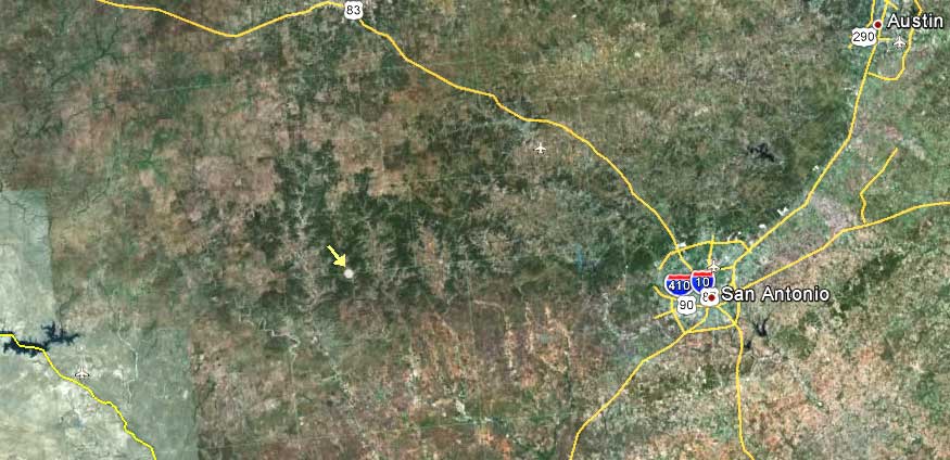
Notice the dark region occupying the area west of Austin, north of San Antonio, and extending westward to the Mexican border -- most of the picture's upper left and upper center. The dark area is the Edwards Plateau. I'm guessing that the dark areas in the picture represent mostly the Plateau's Ashe Junipers. The Mexican border is that yellow line at the picture's lower, left. The big lake across which the border cuts is Amistad Reservoir at Del Rio.
Notice that here at the Plateau's southern boundary the transition to the Coastal Plain is not in the least a well defined front. Everywhere it is cut by streams flowing from north to south. Do you see the white dot with a yellow arrow pointing to it? That's where our pictures are taken, where these words are being written.
The paler land to the south and east of San Antonio is mostly the landscape of the fairly flat and younger Coastal Plain Province