
PLANTS | ANIMALS | ECOLOGY | FUNGI | GEOLOGY | GARDENING | TOOLS
Excerpts from Jim Conrad's
Naturalist Newsletter
from the July 26, 2009 Newsletter, describing a backpacking trip on the Pacific Crest National Scenic Trail in Red Buttes Wilderness Area, Siskiyou County, California:
CIRQUES
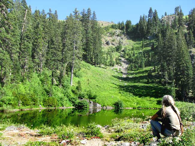
On our first night in the highlands we camped at Echo Lake, elevation around 5450 feet
(1660 m). You get an echo there because high, steep slopes rise on three sides, returning an echo if you call. On the fourth side there's a low, natural dam of jumbled rock and dirt, below which a U-shaped valley opens prettily. Echo Lake itself was circular and maybe 300 feet across. You can see Christie sitting admiring it all above.
Echo Lake, which we found teeming with water striders and Rough-skinned Newts, occupies a classic cirque (pronounced SURK). A cirque is an amphitheater-like valley head gouged out by an alpine glacier. Thousands of years ago a glacier originated where Echo Lake now pools, its ice flowing into and scouring out the valley below.
There's a whole fascinating world of glacial geology with attending specialized terms, such as "cirque." A cirque's lake is called a "tarn," while the highest cliff around the tarn often is called a headwall. The tarn's dam is the "lip." If two adjacent cirques erode toward one another from across a ridge an "arête" is formed. When three or more cirques erode toward one another, a "pyramidal peak" or "horn" is created.
More information, diagrams and pictures outlining the whole cirque phenomenon are outlined on the Wikipedia Cirque Page at https://en.wikipedia.org/wiki/Cirque.