MEXICAN PLANTS & ANIMALS HOME

Excerpts from Jim Conrad's
Naturalist Newsletter
entry from field notes dated January 20, 2023, taken in scrub along ridgetop ~1.5km south of Camargo, elevation ±1,700m (7280 ft); bedrock of fine-grained, calcareous mudrock; Querétaro state, MÉXICO, (N21.09°, W99.73°)
ROADCUT VIEWS OF THE SOYATAL-MEZCALA FORMATION
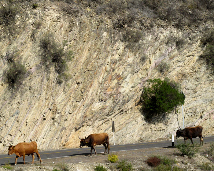
The Mexican Geological Service's Carta Geológico-Minera Peña Miller F14-C47 Querétaro y Guanajuato of 1998, a geological and mining map, places Camargo and a large area around it within a zone of outcropping rock of the Soyatal-Mezcala Formation. This unit is Late Cretaceous in age, maybe 67-90 million years old. Many roadcuts along the very curvy Hwy 120 passing through the area, such as the above, provide a glimpse into the area's geological history.
During the late Cretaceous, dinosaurs roamed the Earth, while early forms of flowering plants began to diversify, producing certain relatively primitive flowering-plant groups familiar to us today, such as magnolias, roses and willows. However, fossils of these organisms don't occur in this area's rock strata because during the Late Cretaceous all of eastern Mexico, including here in the Eastern Sierra Madre mountains, was covered with shallow oceanic water. The bedrock here, despite being so high in elevation, began as sediment at the bottom of a shallow sea. The sediment eventually turned to rock, mostly through chemical processes and compression.
As the ocean floor rose to form the Eastern Sierra Madre mountains, the rock strata often were folded and thrust about. In the above picture, you can see results of this violence. Note the V-shaped fold of the strata coming to a point just in front of the middle cow. Here's a closer look at that fold:
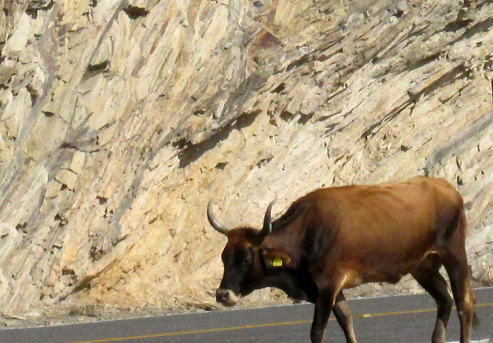
That's a classic example of chevron folds. It's a feature of strata undergoing enormous pressure from the sides, often even as they're being uplifted. In this way our Eastern Sierra Madres, composed mainly of limestone, which is a sedimentary rock, are fundamentally different from the Western Sierra Madres, composed mainly of volcanic and metamorphis rocks. The Western Sierras resulted from the vast Pacific Tectonic Plate scraping against and somewhat beneath the also-huge North American Plate. The scraping friction produced such heat that rock melted and enormous pressure was created, causing the molten magma to surge upward and erupt, forming mountains of igneous and metamorphic rocks.
Chevron folds in such sedimentary strata as seen above typically occur where rocks are composed of strata in which the layers display regularly alternating differences of "stiffness" -- better referred to as different competences. I think of it as the strata remaining straight as long as pressures from the side don't overcome the stiff layers' resistance; but if that resistance is overcome, the stiffer strata fold until the weak layers' resistance suffices to stop the folding, by which time the layering has kinked into chevron folds.
Here's another close-up of rocks along the road maybe 500m uphill:
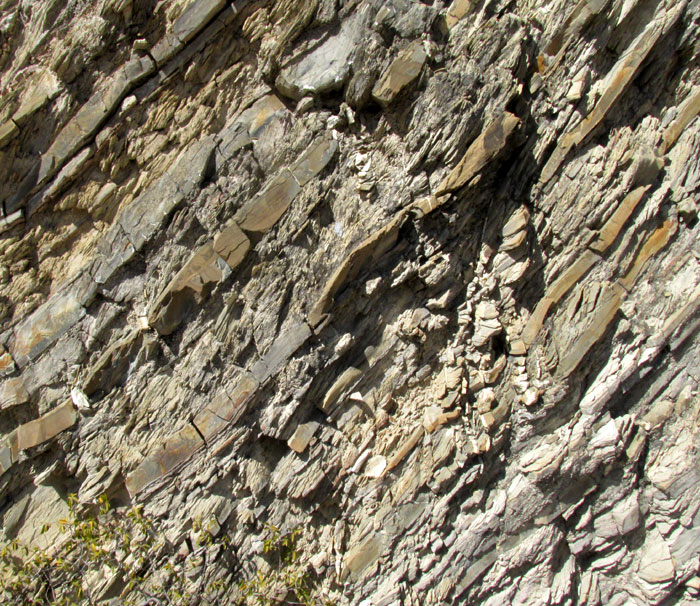
That shows alternating beds, some clearly more vulnerable to breaking -- with less competence -- than others. Note that the smoother rocks are a different color. The reddish smooth rocks are formed of finer grained particles and of different minerals than the whitish crumbly-looking ones. But, what type of rocks are these?
Rocks in this area are described as calcareous turbidites. By "calcareous" is meant that the rocks contain calcium. Earth's main calcareous rock is limestone. Limestone largely consists of the remains of marine organisms that settle to ocean floor when they die, forming sediment, as well as calcium carbonate precipitated from seawater as it evaporates at the surface. The term "turbidites" refers to rocks formed from sediments deposited by water currents clouded or thick with suspended matter. As the sedimentation took place ultimately leading to our rocks, the water was turbulent enough to hold suspended particles in it.
Since calcareous shale often intergrades with limestone, and we obviously have alternating strata of different compositions, probably the best single label for our roadcut rocks is "calcareous mudrocks." Mudrock is a general name for any sedimentary rock consisting of silt- and clay-size fragments. Mudrock is the most common sedimentary rock on Earth.
The Eastern Sierra Madres are an expression of what's often known as the Mexican Fold and Thrust Belt. What causes the enormous pressures from the side causing not only chevron folds but also our mountains to rise from the seafloor?
Fold-and-thrust belts often form at the edges of mountain-building events such as those forming the volcanic Western Sierra Madres, where the Pacific Plate crashed into the North American Plate. The volcanic Western Sierra Madres popped up right next to the crash, and way inland, the sedimentary Eastern Sierra Madres formed. It's like when a car runs into a wall: It crumples well back from the totally smashed front end. Our Western Sierra Madres, like the Rocky Mountains in North America, are such crumples. Wikipedia has a page on the general nature of Fold and Thrust Belts