PLANTS | ANIMALS | ECOLOGY | FUNGI | GEOLOGY | GARDENING | TOOLS
MEXICAN PLANTS & ANIMALS HOME

Excerpts from Jim Conrad's
Naturalist Newsletter
Entry from field notes dated July 1, 2023, taken along road between El Campamento and El Doctor in mountains of east-central Querétaro state, municipality of Cadereyta de Montes, about 12 straight-line kms due east of Vizarrón de Montes but much farther by twisting roads; elevation ~2500m (~8200 ft), Querétaro, MÉXICO, (N20.87663°, W99.61187°)
PEDESTAL EROSION IN A ROADCUT
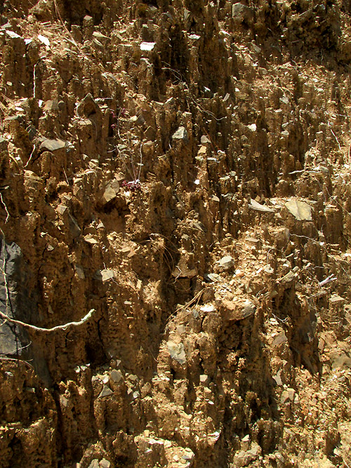
The above shows a small part of the eroded wall of a roadcut where a road was cut across a steep mountain slope. It shows pedestal erosion, often seen when rain erodes soil from beneath an object resistant to the erosional process. It's a commonly seen phenomenon but seldom can such a picture as above be taken of it.
That's because the image was made when the sun at least appeared to be exactly overhead, thus shadows accentuate the pedestal formations. Our location at North 20.877° degrees was not far south of the Tropic of Cancer, at North 23.439° degrees, and today's date, July 1, is only a little over a week after the Summer Solstice on June 20, when the sun stood directly above the Tropic of Cancer.
In the picture it's easy to see how such pedestal erosion occurs. Flat flakes of limey slate were scattered across exposed soil. Falling rain eroded soil from around the flakes, but not beneath them, resulting in pedestals of soil capped by small rock flakes. The flakes had resulted from road construction cutting across the slope's face, passing through a fairly thin stratum of slate surrounded by massive limestone.
This phenomenon occurs on a large scale when soft rock beneath caps of harder rock erodes over long periods of time. In the US, such rock formations are called hoodoos, as well as tent rocks, fairy chimneys or earth pyramids. Wikipedia has a nice Hoodoo page.