PLANTS | ANIMALS | ECOLOGY | FUNGI | GEOLOGY | GARDENING | TOOLS
MEXICAN PLANTS & ANIMALS HOME

Excerpts from Jim Conrad's
Naturalist Newsletter
entry from field notes dated January 17, 2023, taken on trail up the southeast-facing slope of Peña de Bernal on the northwestern side of Bernal, peak elevation ±2,510m (8230 ft); bedrock of intrusive, igneous dacite rock, similar to granite; Querétaro state, MÉXICO, (N20.748°, W99.949°)
PEÑA DE BERNAL MONOLITH
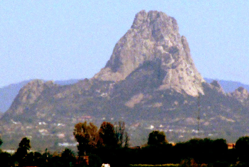
The landscape of this part of upland central Mexico north of Mexico City is mostly flat to gently rolling, with occasional clusters or ranges of hills. The flat and rolling parts are mainly composed of sediment washed from surrounding hills, while the hills are mainly metamorphic or igneous rock. The elevation of the flatland town of Tequisquiapan is around 1877m (6158ft). The above telephoto picture shows the highest peak in the region, Peña de Bernal, about 27km (17miles) to the NNW of Tequisquiapan, where the picture was taken.
On the Internet there's a great deal of conflicting information about Peña de Bernal, partly because it's a tourist destination and travel sites often repeat one another's tourist-attracting hype. The most recent and complete scientific treatment of the Peña I can find is the 2013 work by Gerardo J. Aguirre-Díaz and others entitled "Geologic setting of the Peña de Bernal Natural Monument, Querétaro, México: An endogenous volcanic dome." That publication says of the Peña that "With a measured height of 433 m from its base, it is apparently the highest monolith in the world."
A monolith is a single, UPRIGHT, block of stone. By saying that the Peña is "apparently" the world's highest monolith, the authors appear at least a little uncertain about the matter, as well they might, since in other parts of the world often it's claimed that Brazil's Sugarloaf Mountain rising above Rio de Janeiro is higher, and it's the same with the Rock of Gibraltar.
However, the geologists present convincing evidence that Peña de Bernal is an "endogenous volcanic dome." In other words, the massive block of stone forming Peña de Bernal is of volcanic origin -- not metamorphic or sedimentary -- but the ancient volcanic magma responsible for the rock never was erupted as lava onto the landscape. The mass of molten lava bubbled upward toward the Earth's surface, but never quite broke through it, or maybe it penetrated the surface only a small amount. Consequently, the molten lava forming the bubble cooled in place -- at a much slower rate than if it had been erupted onto the landscape or into water -- to form solid, grainy igneous rock.
The team producing the quoted paper wanted to know when this event happened. For many years geologists assumed that it occurred during the Jurassic Period between 199.6 million and 145.5 million years ago, when dinosaurs were a dominant life form. However, when rock samples from the Peña were examined using both the "K-Ar" and the "40Ar-39-Ar plateau age" techniques, the magma forming the Peña was found to have cooled and solidified about 8.7 million years ago, during the Miocene Epoch of the Neogene Period. That time is known as an active period of volcanism in the Western Sierra Madres. By then, groups of mammals familiar to us had arisen, plus certain groups remained that now are extinct, such as three-toed horses and hornless rhinoceroses.
The authors describe the igneous rock forming Peña de Bernal as "a highly crystalline and very resistant rock, gray to light gray when fresh and brown when weathered." That coincides with what's seen below:
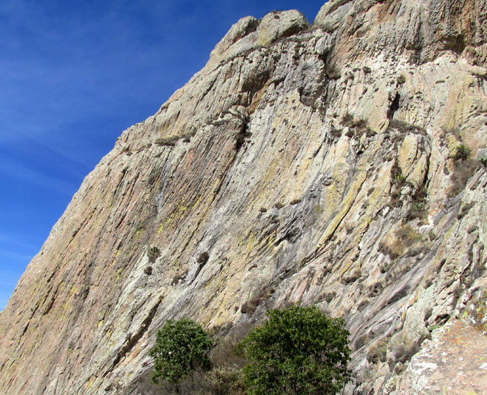
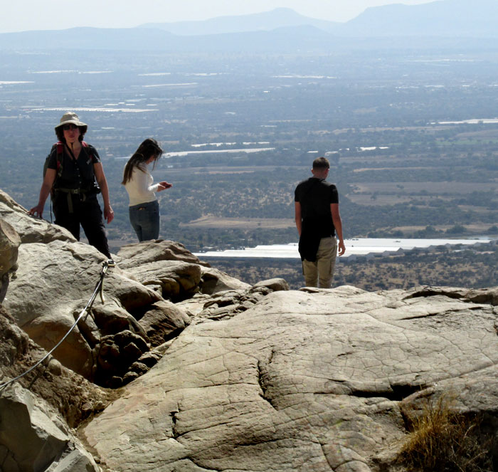
That's a view of the southeast-facing slope as seen from a point on the trail climbing to the base of the face. What appears to be the flowing action of the original magma frozen in place is actually the erosion-exposed edges of thin sheets of magma formed during the cooling process. At the image's lower, right, you can see the sheet nature of some of the exposed rock. Throughout geological time, the monolith surface is exfoliating. Here's a shot of the base of the rock face, at which point the massive bare face of the monolith continues rising on the left, but can't be climbed without standard mountain-climbing equipment.
The authors refer to the Peña de Bernal monolith as a "dacitic dome." The term dacite is used to describe a fine-grained, light gray, volcanic rock type. The rock itself was found to be composed of up to 80% by volume of crystals, and 20% matrix glass. The crystals were formed from of a variety of minerals, including plagioclase, orthopyroxene, hornblende, biotite, sanidine, quartz, iron-titanium oxides, apatite and zircon.
The "dome" part of Peña de Bernal's dacitic dome refers to what can be visualized as the top of a bubble of molten lava that forced its way upward through the Earth's crust. However, the top of the bubble never reached the land's surface, at least not in a dramatic way. Today Peña de Bernal thrusts far above the landscape's surface because throughout geological history the older rock strata around the bubble eroded away. The dome itself also continued to rise somewhat as it continued cooling, forming solid rock.
Finally, back to the "dacitic" part of the Peña's dacitic dome. The authors seem quite clear that Peña de Bernal's rock type is dacite. However, the official 2007 geological map of the Servicio Geológico Mexicana entitled "Carta Geológico-Minera Tequisquiapan F14-C67 Querétaro e Hidalgo" characterizes Peña de Bernal's rock type as granodiorite. The map makers do say that details of the map are subject to revisions. Since the map is older than the 2013 investigation quoted above, I'm using the 2013 dacite term. Moreover, when I compare the geological definitions of granodiorite/diorite and dacite, there's a great deal of overlap, with no clear distinction between them.