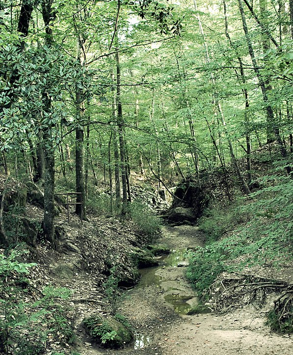
 Loess Hills forest; copyright free image courtesy of Tiffany Bailey of New Orleans, Louisiana
Atop the cliffs, hilltops and on ravine slopes along the Mississippi River floodplain's eastern side, from western Kentucky to northern Louisiana, the forest is lush and diverse, like what's shown in the Mississippi forest at the right. Dark and shadowy, with fabulous trees like Flowering Dogwood, Persimmon, Sourwood, American Holly, Sassafras, Honeylocust, Redbud, Chinkapin Oak, Parsley Hawthorn... Just writing those names evokes rich, fungusy odors and cooling cool shadows, birds singing and butterflies flitting. You might enjoy looking over a list of trees identified in a certain Loess Hills forest area just south of Natchez, Mississippi.
Something interesting is that if you start on a long bike ride one morning, beginning near a loess-capped cliff bordering the Mississippi's eastern floodplain, and head east, before long you'll start noticing the forest changing. In general, it's a mosaic of forest types reflecting how long ago the last cutting was, hill slope and such, but mile after mile the patches in the mosaic begin seeming "thinner" than they were at the beginning. More light enters among the trees, and the understory less lush. Even the odor changes from moist mustiness to a certain dusty, resiny smell, sharper and hotter.
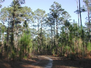 Longleaf Pine forest; copyright free image courtesy of "Pollinator" via Wikimedia Commons
What you're seeing is the Loess Hill's broadleaf hardwood forest being replaced by southern pine forest.
The reason it's happening is that as you travel eastward away from the Mississippi River, the soil's loess mantel becomes thinner and thinner, and the fertilizing, organic-matter-holding, available-water-retaining benefits of loess are diminishing.
During the 1960s, a team from Millsaps College in Jackson, Mississippi, headed by J.O. Snowden, Jr. and Richard Priddy, conducted a battery of tests on Mississippi loess. The results of one of those tests, showing that, in general, the deeper the original layer of loess, the greater the later soil's diversity of plant species per unit area, is shown below:
| # SPECIES PER SAME-SIZE PLOT | ||
| THICK LOESS ±40 tree spp. ±51 shrub spp. >66 herb spp. |
THIN LOESS 15 tree spp. ±34 shrub spp. >49 herb spp. |
UPLAND NON-LOESS 13 tree spp. ±38 shrub spp. >44 herb spp. |
LOESS-HILL RAVINE/BAYOU WALLS
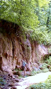
The world inside the loess zone's deep, steep-walled ravines, or bayous, looks, feels, and is different from the outside world. As suggested by the picture at the right taken in a bayou just south of Natchez, Mississippi, for much or all of the day the often-narrow ravines' steep to vertical walls block the sunlight, even as overhanging vegetation shades or filters it.
Similarly, wind has a hard time reaching deep into the ravines. On an average summer day often leaves can be heard rustling among trees outside the ravines but, there may be a dead calm, and a musty odor to boot. Protection from the wind means a lot to many ravine-dwelling species because wind can dry out the air, and during the winter it carries freezing temperatures wherever it blows. The ravine shelters many species who can't stand the dryness, the coldness, and maybe even much sunlight itself.
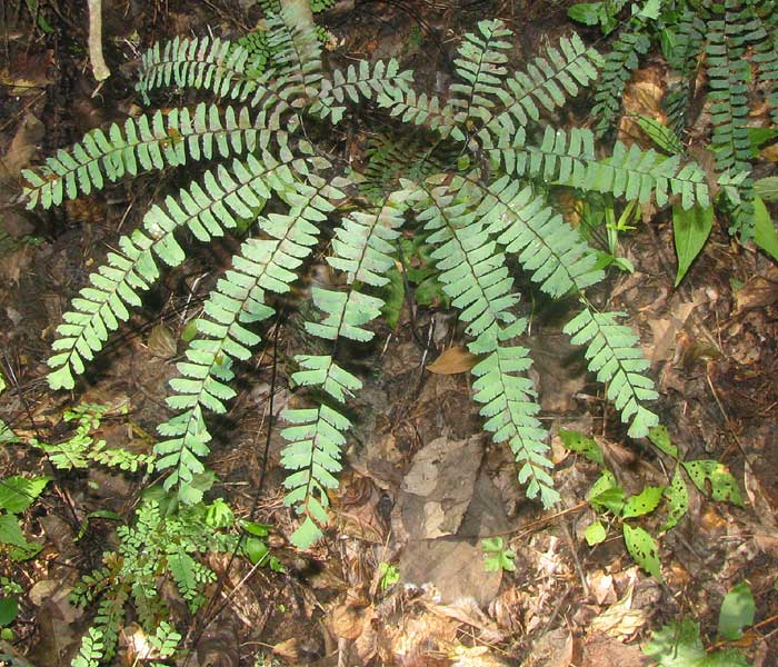
Some species sheltering in our ravines/bayous are flexible enough in their habitat requirements that they also occur outside the ravines, but others, at least locally, can't survive outside them in all that dryness, windiness and sunlight. They are truly taking refuge in the ravines and, at least locally, must have them to survive. The Northern Maidenhair Fern at the left is typical of such plants; the species reaches its southernmost North American distribution in Loess Hills ravines in southwestern Mississippi and northeastern Louisiana, where its northern inclinations for coolness and moistness are fully satisfied.
RAVINES/ BAYOUS AS SUPERHIGHWAYS
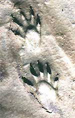
Among our Loess Hills, wherever ravine/bayou bottoms are sandy or muddy, you see lots of animal tracks. These ravines bottoms just make great walking for everyone. Those are Raccoon prints at the right.
Foremost among the tracks are those of Whitetail Deer, Coyote, Red Fox, and, surprisingly often, feral hogs, who may root up large areas of streambeds. 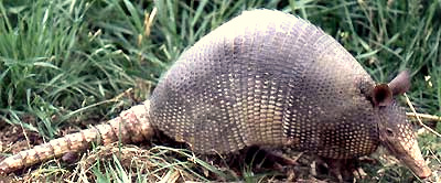 Among smaller animals Armadillos like the one at the left partly obliterate their prints as their heavy tails drag behind, Raccoons leave prints like little human hands, Opossums display their backward-pointing "thumbs," and even the occasional Eastern Gray Squirrel comes down from the trees, leaving marks in mud showing long, needle-like nails. During certain times of the year you see sprays of dirt being ejected from beneath the roots of a tree clinging to the slope's wall. where a Chipmunk is busy excavating its tunnel.
Local folk often avoid walking in ravines for fear of snakes. In our experience, snakes, particularly poisonous species, are less common in ravines than outside them. Nonetheless, one should always follow two main snake-avoiding rules:
- Don't place hands and feet anyplace you haven't visually scanned.
- Don't step over logs and rocks which may have snakes resting behind them