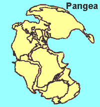
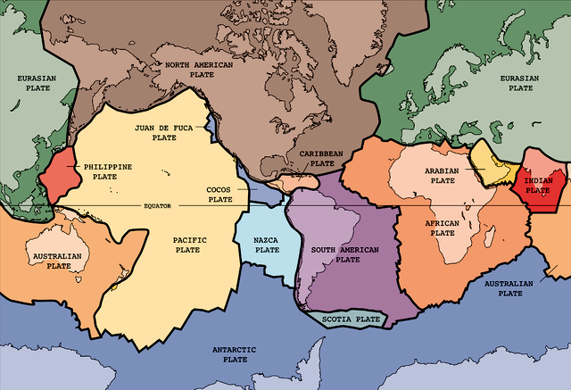
When Pangea broke up, once again big plates of crust slowly drifted apart, some eventually crashing into one another, causing earthquakes and volcanoes, and entire mountain ranges to rise. Below, you can see the current state of things:
The illustration below shows the directions in which the major plates are wandering.
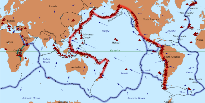
Note that along South America's western coast an ocean plate drives eastward as South America itself progresses westward. The plates' collision results in the Andes Mountains. The Indian Plate shoots northward, colliding with the Eurasian Plate moving southward, and up pops the Himalayan Mountains. Red triangles represent volcanoes, and it's notable that many volcanoes line up in the form of a partial circle, the Ring of Fire, more or less bordering the Pacific Ocean.
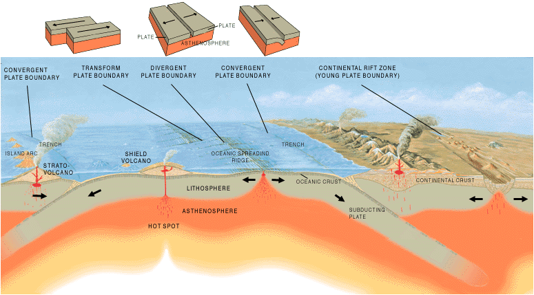
The chart below starts explaining how this continent-wandering affects the Earth's landscape:
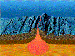 Mid-ocean ridge topography with magma chamber below, which rises and new ocean plates spreads away from ridge; image courtesy of US Geological Survey
Above, note that the plate with the ocean on it is slipping beneath the plate covered with land. The friction caused by this contact causes heat, expressing itself at the land's surface as erupting volcanoes. Also note that the ocean-bearing plate has a region labeled "oceanic spreading ridge," at which each side of the the ridge moves away from the other -- as shown at the right -- suggesting part of the mechanism enabling continents to wander.
Often you see the concept of plate tectonics referred to as a "theory." It's true that certain features of the wandering continent process are unclear and debated. However, no serious expert refutes the basic facts: There are enormous crustal plates; the plates move; some shrink while others grow, and; sometimes they bump into one another causing enormous changes in the landscape.
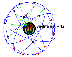 simulation of the GPS space segment; image courtesy of 'El pak' and Wikimedia Commons
A satisfying "proof" of wandering continents is that nowadays with help of a global network of satellites making possible GPS, the Global Positioning System (simulated at the left), the direction and velocity with which land masses are wandering can be measured. The US government official GPS page explains the system.
Thanks to GPS measurements, on the US's NOAA page entitled What is Tectonic Shift, it's possible to state that the average rate of the Earth's land masses moving toward and away from one another averages about 0.6 inch per year (15mm). Some regions, such as earthquake-prone coastal California, move almost two inches per year (51mm).
You can learn much more about continental drift and geological processes associated with it at the Berkeley University Plate Tectonics Site, where you can even view an animation showing how the continents have drifted during the last 750 million years. At the DinosaurPictures.Org website, plug in a city's name, choose how long ago you want to see the Earth, and you'll learn how the continents were spaced around the city's location at that distant time.