 March 15, 1988
CALIFORNIA: Riverside County
Beside the Salton Sea two miles southeast of Salton Beach
March 15, 1988Comprising a finger of heaped-up sand about forty miles long and five or six miles wide, the Imperial Dunes run northwest from the Mexican border to about twelve miles east of Calipatria. On I-8 heading west from the dunes, first we pass from sand and scattered Creosote-bush into Mesquite, then twenty more miles bring us into the region called Imperial Valley. Compared to everything seen since leaving Amistad, this region is lush and glossed over with a mellow, suburban atmosphere. Today farmers are clipping alfalfa, filling the air pouring through Henry's open windows with sleepy, pastoral and herbaceous odors. Stacks of brown, curing hay line the roads and field edges -- stacks maybe ten bales high and 200 bales long. Sugarbeets, cabbage, lettuce, wheat... all imparting their special hues of green to the landscape.
Then broad streets, shopping malls, busy intersections, and suddenly I'm in mainstream America again, wondering how it all happened with no warning at all. Until now to hear the news on the radio, each place we've stopped I've had to wait until night fell, then tune in the long-distance AM stations; but approaching the Palm Springs/ Indio area, the FM radio band fills with stations from one side of the dial to the other. During this trip I've been starving for classical music but now suddenly on the FM band's lower side the world's greatest orchestras lie packed unceremoniously side by side. Somehow I resent my desert isolation having been so quickly and with no warning taken away.
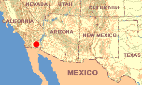
El Centro represents an important milestone for us. Until now the headset has been to move west -- "stay near the Mexican border and go west," I told Henry. At El Centro we abandon I-8, turn right and head north on CA Hwy. 86. Henry's instruction now becomes, "Go north until it's time to head back east, toward home."
El Centro lies forty-five feet below sea level. About ten miles farther north, Brawley says it's sunk to -119 feet. Finally the shimmering, blue Salton Sea appears on our left, its water level at 232 feet below sea level. Pulling up to a camping spot right at the water's edge, when Henry's engine rolls to a stop, I hear the sound of waves splashing against the yard-high, vertical, dirt bank beside us.
All streams and rivers in this area drain into the Salton Sea. The Sea has no outlet. This thirty-mile long, fifteen-mile wide body of water lies in the bottom of a great trough extending from Indio in the north to just inside Mexico, west of Mexicali. The San Andreas Fault runs through here. My maps indicate that at this very moment I could not be more atop the fault. So here I sit visualizing the vast tectonic plate to the southwest grinding beneath the plate to the northeast, causing the land to subside. However, the depression doesn't fill with water to sea level because water draining here evaporates faster than rain can replenish it. My National Geographic map states that the Salton Sea formed between 1904 and 1907 when the Colorado River, which runs between southeastern California and southwestern Arizona, overflowed its banks.
The temperature at 1:00 PM is 80º in the shade. Though it's very hazy -- smoggy -- across the lake, to the west I see the Santa Rosa Mountains, with Rabbit Peak rising to 6650 feet above sea level. On the water, Ring-billed Gulls float complacently near shore while farther out six White Pelicans are a welcome sight. Barely identifiable because of their distance from shore, fourteen Eared Grebes make themselves at home on open water. As if rushing to an important meeting, low above the water right offshore come three Double-crested Cormorants.
On this flat-surfaced plain gently sloping toward the water, at least one blossoming plant qualifies as a wildflower. It's one of those ubiquitous, yellow-blossomed members of the Composite Family, the Desert Sunflower, Geraea canescens. Two feet high and with soft, fuzzy leaves like burro's ears, it holds 1-inch wide flowers atop reddish, gangling stems.
Maybe the most interesting plant here is Pickleweed, Salicornia sp. Its leafless, segmented stems look like pea-sized, green, semi-cylindrical beads stacked atop one another. Succulent and brittle like canned sweet pickles and tasting salty, it's a halophyte, one of those plants adapted to especially salty soil.
Maybe another dozen species of small plants and bushes can be found flowering here, but the sudden pleasure of being next to this wonderful body of water just takes away a lot of my botanizing urge. I just want to walk along this shore.