 March 1,
1988
March 1,
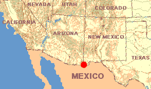
1988NEW MEXICO: Hidalgo County
Coronado National Forest three miles east of the Arizona border and fifteen miles north of the Mexican border, in the Peloncillo Mountains. Elevation between 6000 and 7000 feet.
March 1,
1988Leaving Big Bend, now we head north through Alpine
and Marfa, then at El Paso enter New Mexico and continue west on I- 10. At Las Cruces we
climb fast toward a moody, close-up horizon. Clouds boil over some kind of earth-rim, then
skate low right above us. Eighteen miles west of Deming a sign reads "Continental
Divide/ Elev. 4585 feet." I look around at nothing but some low hills miles away and
along the road a grassy flatness punctuated with a few scattered Soaptree Yuccas about fifteen feet tall and I ask
Henry how anyone could make a divide out of this. A few miles later I notice that the
chugging sound emanating from the little hole in Henry's muffler isn't as labored as it
was before the "Divide," so maybe earlier we were climbing up, and now we began
coming down. Still, this seems a pretty tentative way to divide a continent.
We're heading toward the Peloncillo Mountains Wilderness Complex
in the easternmost unit of Coronado National Forest, the southernmost national forest in the
western continental U. S. It's down in the boot-heel of New Mexico, where New Mexico,
Arizona and Mexico all come together. Two of my books place this area in
the Chihuahuan Desert but another shows it as an undefined spot between the Chihuahuan and
Sonoran. I consider it a transitional zone between the two great deserts. I'm curious to
see what kind of forest might exist in such an out-of-the-way place, but the main reason
for going there is that after Big Bend I'm aching for cool, shaded moistness.
Twenty miles of rough gravel road south of Animas brings us there. Suddenly the wind
gushing through holes in Henry's rusted floorboard feels surprisingly cold. A heavy
overcast forms above us for the first time since leaving Amistad, and then about a hundred
raindrops splash onto Henry's windshield. Though we must be high in elevation, at no time
during the last fifty miles have we climbed steep slopes -- it's all been gradual, with
the only hints that we've been climbing being the change in weather and Henry chugging a
little louder than usual.
Coronado is a laid-back national forest with no formal campgrounds and nobody around -- no
rangers and no campers. Rolling, windswept, grasslands break into medium-size hills, trees
appear, and that's the forest. The feeling is more of suddenly penetrating a region of
valleys with incidental hills between them, than that of entering a place where hills rise
from a plain. Maybe the distinction is more important psychologically than ecologically.
On the
valley floor trees stand between ten and twenty feet tall. On the slopes they're more
scraggly and widely spaced, and seldom rise higher than ten feet.
This forest feels strange. A certain disjointed or "crooked" feeling permeates
the cold, tingling-fresh air. It'll be fun to identify things, to see if the plant and
animal species here are as exotic as the forest's feeling.