 February 9, 1988
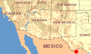
TEXAS: Brewster County
K-Bar Campsite in Big Ben National Park; elevation about 3000 feet.
February 9, 1988
Now knowing, more or less, what winter at the edge of the Chihuahuan Desert is like, having settled into a daily routine and having been accepted into the society of old fishermen daily congregating below the seep-willows, on a certain day, almost surprising myself, I leave Amistad to begin this trek through four deserts. My immediate goal now becomes to experience winter deep inside the Chihuahuan Desert, not just realities at its edge.
Heading west on US 90 toward Marathon, the land undulates like the ocean swelling at a storm's edge. Always it becomes drier and drier and sometimes the Cenizo, Leucophyllum frutescens, disappears, but then great waves of it come back again, and then it disappears once more. At Marathon I turn south onto US 385, passing a sign saying, "Big Bend 69 miles." At Panther Junction Park Headquarters I explain my project to a ranger and request a cross-country backpacking permit good for three weeks.
"First of all," says the ranger, "if you've come to learn about winter in the Chihuahuan Desert, you've just about missed it. Another week or two and it'll start getting downright hot, and what passes for spring in these parts will come on fast. Second, if you've never walked cross-country in the Chihuahuan, I strongly suggest that you park your car at one of our designated primitive campgrounds and, using it as a base you can return to each night, take some day-hikes into the desert -- make some 'test walks' before you really take off." I'm given a map of the area that looks pretty good.
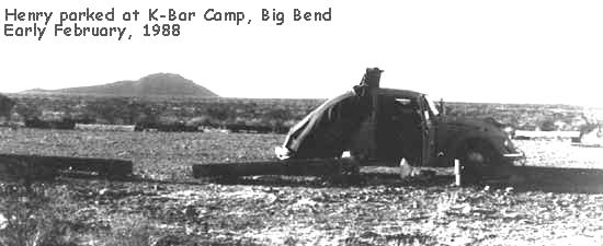
The ranger's proposal sounds reasonable so a camping permit is requested for a spot on the map referred to as K-Bar. Heading to K-Bar I visualize arriving in a cozy little spot surrounded by a few acacias and mesquites, and maybe with a spring nearby, and some trash. But K-Bar turns out to be nothing but a turn-around at the end of long, straight, pot-holed gravel road, with no trees, no water and no garbage. Nothing but open, sun-baked, wind-swept barrenness. I turn off Henry's engine and hear wind whooshing around his corners. The sunlight is heavy and shadows are desperately black: dust, gravel, sunlight, wind... To the west rises very rugged, picturesque Emory Peak, elevation 7,835 feet (2,388 m). I'm at about 3,000 feet.
The dominant plant here is Creosote-Bush, Larrea tridenta. Covered with small, dark-green, gummy leaves, it's almost waist high. Two kinds of knee-high, ashy-white shrubs grow between the creosote-bushes. One is a small close-relative of Amistad's Cenizo; it's Purple Cenizo, Leucophyllum candidum.The other is a kind of Parthenium. Also lots of winter-killed gray and white bunch- grasses with blades tattering in the wind. Interesting peaks and cliffs lie a few hours walking distance off.
This whole flat landscape tilts toward the northeast. Some kind of magnificent geological force has been at work here. A couple of miles toward the south, a small, rocky hill rises from the flatness so I begin walking toward it.
Quickly I learn that Big Bend feels different from Amistad. The cenizo at Amistad was thornless so even when I had to plow through it I didn't get scratched. Here, among the creosote-bushes grows an abundant, pernicious kind of agave with sharply pointed leaves, called Lechuguilla, Agave lecheguilla. Spiny cacti, so easy to walk into, also are much more common here than at Amistad.
Here jackrabbits, Lepus californicus, flee much more fearfully than did the ones at Amistad. Though the sky is blue, somehow it seems to be brooding. The wind feels raw and threatening. As I walk across this isolated, wind-thundery stage, a certain kind of lonely apprehension builds in me. Plucking some creosote-bush leaves, I sniff their medicinal odor, just to bring to mind Dog-Bill teaching me the plant, he with his red face and his breeches falling down, and now somehow I feel better.
As I walk, lechuguilla becomes the thing I focus on most. Picture this: Surely at one time or another you've had the agave called burn-plant or aloe vera. Burn- plant is closely related to the lechuguilla and looks a lot like it, except that the lechuguilla is dried-out looking, has rock-hard spines on its leaf-tips, and bears low spines along its blade margins. Lechuguilla grows in bunches, so usually between ten and thirty plants form a dense, impossible-to-walk-through thicket. In most lechuguilla thickets there's at least one plant sending up a flower stalk six to thirteen feet high. When any agave flowers, it dies - - its leaves and flower stalk wither and fade. Looking across the desert now I see thousands of spent lechuguilla flower-stalks. I'm reminded of the old Ben-Hur movie when the warrior multitudes marched with their spears silhouetted against the anxious, pre-battle sky...
Back at Henry, bending over to untie my over-the-ankle hiking shoes, I find the entire top of my left foot's wool sock soaked with blood from a deep puncture. While cleaning this cut I notice on my left leg's opposite side a lechuguilla spine still sticking one-quarter of an inch into my flesh. From the right leg I remove three cactus spines, one buried half an inch beneath the skin. I'm embarrassed. I'm supposed to be able to do better than this. If each day I am as reckless as today, I'll ruin my legs.
Curiously, however, as much as I feel chastened, also I feel pleased. It's as if I have signed up to study under a master philosopher -- an unseen desert guru -- and now I find that if I do not complete my studies properly, I'll suffer from his severe discipline. But if I truly learn about the desert here -- if I survive -- the experience will be exquisite.