 January
20, 1988
January
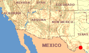
20, 1988TEXAS: Valverde County
US 377 North Campground in Amistad National Recreation Area 7 miles north of Del Rio
January
20, 1988While most days at Amistad are sunny and pleasant (though usually very windy), for the last three days and nights a kind of wetness that's half heavy fog and half drizzle has clouded around us. The wind is almost vicious.
During these days and nights I've stayed in my tent just keeping warm, reading. Especially I've been reading about deserts. Here is some of what I've learned:
First, I've been wondering about the words "chaparral" and "scrub." My Webster's Dictionary claims that the restrictive meaning of "chaparral" defines a community of shrubby plants, especially evergreen oaks, in southern California. In the more general sense, chaparral is a thicket of "shrubs, thorny bushes, etc." Thus, this cenizo-dominated vegetation at Amistad is chaparral in the general sense, but not in the specific sense. Also the dictionary describes "scrub" as "short, stunted trees, bushes, or shrubs" growing together thickly. Therefore, our general-sense chaparral also is scrub. It appears that the terms chaparral and scrub can be used interchangeably.
In this tent I've learned that North America is home to four main hot deserts. The term "hot desert" excludes regions of the far North which, because of low precipitation rates, may be classified as deserts, despite snow and ice covering the land. Today I have designed an itinerary that will carry us through all four of the U.S.'s hot deserts. Here is a list of those four deserts, in the order in which we'll visit them:
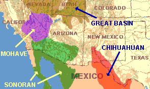 We're at the edge of the Chihuahuan now. This desert
extends farther south than any of the other three. In fact, over 90% of the Chihuahuan
lies in Mexico, mostly in the Mexican states of Chihuahua and Coahuila.The Chihuahuan's
distinguishing features are its great diversity of cactus species, and the fact that it's
a high-elevation desert. Mostly it occupies a plateau region above 3500 feet in elevation,
between the Eastern and Western ranges of the Sierra Madre Mountains. Because of the
elevation, winter temperatures in the Chihuahuan can remain below freezing for over
seventy hours, and summer temperatures average ten to twenty degrees cooler than in the
Sonoran Desert.
We're at the edge of the Chihuahuan now. This desert
extends farther south than any of the other three. In fact, over 90% of the Chihuahuan
lies in Mexico, mostly in the Mexican states of Chihuahua and Coahuila.The Chihuahuan's
distinguishing features are its great diversity of cactus species, and the fact that it's
a high-elevation desert. Mostly it occupies a plateau region above 3500 feet in elevation,
between the Eastern and Western ranges of the Sierra Madre Mountains. Because of the
elevation, winter temperatures in the Chihuahuan can remain below freezing for over
seventy hours, and summer temperatures average ten to twenty degrees cooler than in the
Sonoran Desert.
Shaped like a horseshoe fitted around the head of the Gulf of California, about two-thirds of the Sonoran lies in Mexico, in the states of Sonora and Baja California Norte. In contrast to the Chihuahuan, most of the Sonoran lies below 2000 feet in elevation. Off all the deserts, the Sonoran offers the greatest diversity of species.
The smallest of North America's deserts, the Mojave lies mostly in southern California and the southern quarter of Nevada. Its topography is dominated by north-south running mountain ranges. Three-fourths of it lies between 2000 and 4000 feet; one of my books calls it a "cool" hot desert.
Besides being our largest desert, the Great Basin Desert is the most northerly of our four and, lying mostly above 4000 feet, it's also our highest. Stretching from southern Oregon to northern Arizona, and southwestern Wyoming to along the Nevada/ California state line, it's our coldest hot desert. Whenever the books refer to the Great Basin Desert, invariably they use two words: "saltflats" and "sagebrush."
Here's some more desert information: About one-seventh of the earth's land is classified as desert. If we consider our four deserts as just one big North American desert, it ranks fifth in size among the world's. Larger than our desert are, in order of descending size, North Africa's Saharan, the Australian, the Arabian, and southwestern Russia's Turkestan Deserts.
There are reasons why deserts are where they are. Here's one of the main ones:
Hot, moist air rises at the earth's equator. Since cool air holds less moisture per unit volume than warm air, and since the equator's warm, moist air cools as it rises, it dumps part of its moisture load at the equator, and that's why many equatorial regions are so lush. When this rising, drying-out equator-air can rise no farther, it splits into two streams -- one flowing northward and the other heading toward the south.
Because of reasons relating to the Coriolis force and the fact that at the two poles all this equator-air just can't find enough landing-room, much of the dried-out air descends to the Earth far before it reaches the poles -- in the regions of the Northern Hemisphere's Tropic of Cancer and the Southern Hemisphere's Tropic of Capricorn. As this descending air above the two tropics warms, its capacity to hold moisture increases. This increasing capacity translates into lower relative humidities. In short, this air is dry.
Therefore, the world's major deserts lie clustered along the two tropics. Along the Northern Hemisphere's Tropic of Cancer lie our North American deserts, the Saharan, Arabian, Indian and Iranian. Along the Southern Hemisphere's Tropic of Capricorn are found the Australian, Kalaharian, Namibian, Atacaman and Patagonian.
Deserts also form because of rain-shadows. The Great Basin Desert lies considerably north of the Tropic of Cancer, so its location is explained by the rain-shadow phenomenon. Think of moist winds blowing toward the east, coming off the Pacific Ocean. Encountering California's Sierra Nevada Mountains, they find no place to go but up. The rising moist winds cool and drop their moisture loads on the western slopes, providing water that flows into the rich Sacramento and San Joaquin Valleys. When the warming, dried-out winds descend on the eastern slopes and stream eastward across the Great Basin, they're rained-out desert winds.
Other reasons for deserts exist, too. But in this wet tent, the two main causes outlined above are enough to think about.