PLANTS | ANIMALS | ECOLOGY | GEOLOGY | GARDENING | TOOLS
MEXICAN PLANTS & ANIMALS HOME

Excerpts from Jim Conrad's
Naturalist Newsletter
from the November 19, 2007 Newsletter issued from Yerba Buena Clinic just outside Pueblo Nuevo Solistahuacan, Chiapas, MÉXICO
about 1740 meters in elevation, ± LAT. 17° 11' 27"N, LONG. -92° 53' 35"W
CHIAPAS'S GENERAL PHYSIOGRAPHY
Below you can see how Chiapas's landscape can be divided into seven physiographic units.
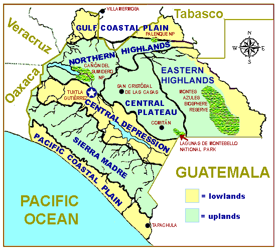
On that map the chilly uplands are greenish while the hot lowlands are tan color. Notice that Yerba Buena resides in the center of the Northern Highland section. Here are notes on the seven physiographic units:
1) The Gulf Coastal Plain in the north is a hot, humid, lowland area currently largely underwater because of heavy rains and runoff from the deforested slopes of the next two regions. Originally marshes and patches of borderline rainforest grew on the Coastal Plain alluvium but now most of the lowland has been converted to pastureland and banana plantations.
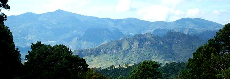
2 & 3) The Northern & Eastern Highlands consist of alternating mountain ranges and valleys, mostly between 1200 and 2200 meters high (4000-7200 ft). You can see a typical view across a typical valley at www.backyardnature.net/n/07/071119gl.jpg. Mountain slopes harbor a variety of vegetation types, depending on elevation and exposure, but deforestation has devastated the ecology of all slopes.
4) The Central Plateau is a chilly highland mostly between 1200 & 2200 meters in elevation (4000-7200 ft) that can be hilly but isn't deeply dissected like the Northern and Eastern Highlands. Bedrock is mostly Cretaceous limestone developing karst topography, with some volcanic outcrops. Pine species are most common in most places but sometimes oaks predominate. Logging, firewood gathering and farming has impacted the area tremendously.
5) The Central Depression is a hot, relatively arid lowland dominated by much-disturbed, low, spiny scrub forest growing on alluvium between 420 and 800 meters (1400-2600 ft) in elevation. Much of the foothills' semideciduous woodland has been converted to coffee plantations.
6) The Sierra Madre of Chiapas is a mountain chain averaging 1500 meters (5000 ft) high in the northwest to 3000 meters (9800 ft) in the southeast, composed mostly of granitic and metamorphic rock of Precambrian and Paleozoic age. Chiapas's highest peak, Tacaná Volcano, rises to 4,060 meters (13,320 ft) on the Guatemalan border. These altitudinal variations support many vegetation types, much impacted by man.
7) The Pacific Coastal Plain is a band of hot, lowland alluvium 20-30 kms broad (12-19 miles) along the entire Pacific coast. Originally this region was occupied by thorn forest but now it's been cut, burned and converted mostly to open agricultural wasteland with little of the natural forest remaining. Species-rich mangrove forests sometimes occur between shore and the sea.