THE ANCIENT MAYA
The ancient Maya civilization reached its peak of power and glory during
its "Classic Period" between AD 250-900. The great city-states of that time
included Tikal in Guatemala and Calakmul is southern Campeche state, Copán in Honduras,
and Palenque and Yaxchilan in Chiapas. Here along the Yucatan Peninsula's northern coast,
we were far from most of the action, though long distance Maya traders visited in their
merchandise-filled canoes, and certain northern Maya cities did exist at this time, such
as Dzibilchaltun
ten miles north of Mérida
MAYA RUINS IN THE BIOSPHERE
At least 18 archeological sites are identified within the Reserve area. Of these,
Mexico's Instituto Nacional de Antropología e Historia considers the site of Emal
the most important. Other sites occur near El Cuyo. When the
access road to El Cuyo was built, stones from the ruins were used. Along the estero's
margins, three concheros or conchales -- zones where the ancients left
significant accumulations of shells from their meals. In a location known as Alegría
six sites are reported, but so far have not been studied, and no efforts are being made to
conserve them.
During the 800s, the great classical Maya powers south of the Yucatan mysteriously suffered
major political collapse. Cities were abandoned, great dynasties were ended, and Maya
activity shifted northward. Closer to our area, the cities of Chichén Itzá and Uxmal grew and became more
important. Chichén Itzá became what was probably the largest, most powerful and most
cosmopolitan of all Maya cities. However, even Chichén Itzá eventually lost most of its
power, by about 1250.
With Chichén Itzá gone, Mayapán 40 kms southeast of Mérida became a power, more or less
uniting the northern Yucatan's Maya under one government. However, in 1441, Mayapan itelf
was sacked, burned, and abandoned. All the region's larger cities went into decline, and
Yucatan's Maya populations devolved into warring city states.
Thus, when the first Europeans arrived in the Yucatan, Maya civilization
already had reached its peak and collapsed. There were plenty of Maya people still occupying the land, but Maya power and glory were long past.
*****
FIRST PUBLISHED MENTION OF RÍA LAGARTOS
 The first published
mention of the estuary now known as Ría Lagartos was in a map accompanying the 1511
publication De orbe novo by Peter Martyr
d'Anghiera. Click on the thumbnail at the right to see the map in larger scale.
The first published
mention of the estuary now known as Ría Lagartos was in a map accompanying the 1511
publication De orbe novo by Peter Martyr
d'Anghiera. Click on the thumbnail at the right to see the map in larger scale.
In 1517 the Spanish foot soldier Bernal Díaz
del Castillo was part of an expedition of Francisco Hernández de Córdoba along the Yucatán Peninsula's
northern coast. In 1632, after Bernal's death, his Historia verdadera de la conquista de la Nueva España was
published, in which, in the fifth chapter, he mentioned visiting the estuary. He wrote:
"Y había en aquel estero muchos y grandes lagartos, y desde
entonces se puso por nombre el Estero de los Lagartos, y ansí está en las cartas de marear"
("And in that estuary there were so many big lizards that it has
always been called El Estero de los Lagartos, by which name it is marked on the charts.")
Download the full text the Historia in the original Spanish here (4.3mb).
*****
SPANISH CONQUERERS ARRIVE
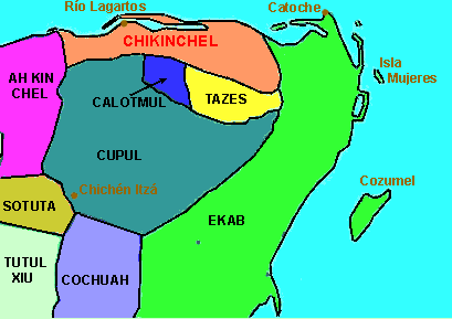
When Spanish conquistadors arrived in the Yucatan Peninsula the Maya world was divided into various chiefdoms. The Ría Lagartos area belonged to the chiefdom of Chikinchel. The following map shows chiefdoms of the Yucatan Peninsula in 1500, according to Ralph Roys of Tulane and the University of Washington, and the Carnegie Institute. The map is based on a copyright-free Wikipedia image.
The Spanish conquerers described the citizens of Chikinchel as refined in their manners
and speaking. The chiefdom's principle city was Chauaca, beside a freshwater lake, near
where the city of Valladolid originally was built, about 14kms south of present-day El
Cuyo, and where little is to be seen today but Maya ruins, the tallest of which rises
about 12 meters. On the above map, Chauaca was about where the H is in the red-printed
Chikinchel. Later the Maya inhabitants were concentrated by the Spanish in what presently
is Tizimín. In 1579, only 20 Maya families lived where once Chauaca had flourished.
During the 1500s, Ría Lagartos Estuary was famed among the Maya for
producing such fish as Snook (Centropomus undecimalis), & Spotted Seatrout (Cynoscion
nebulosus), and Red Grouper (Epinephelus moriomero), which were transported
overland to the new cities of Valladolid and Mérida. At this time at El Cuyo a Maya port
was in operation. Today a pyramidal structure between six and seven meters high exists
(±20ft) atop a platform of about two meters height (7ft). Today a modern lighthouse
stands atop the pyramid.
Taking into account the above map of Chiefdoms of the Yucatan Peninsula in
1500, it becomes easier to accept an assertion of Restall and Hostettler in 2001, that
during colonial times the indigenous inhabitants of the Yucatan
peninsula did not see themselves as members of a common ethnic group.1& The concept of their constitution a "Maya people" was imposed from the outside. Some believe that "the Maya" began to think of themselves as one people only during the Caste War (1847 to 1901).
*****
COLONIAL TIMES
Once Spanish soldiers occupied a region, the encomienda system
was established, which was basically slavery, with the Maya forced to pay tribute to and
work for Spanish soldiers, Spanish colonists and others. In an effort to convert the
indigenous people to the Catholic faith, Franciscan priests built more than 30 convents in
Yucatán, including one in Tizimín just south of us, in 1563. In 1562, Franciscan monk
Fray Diego De Landa ordered all handmade Mayan books and statues to be destroyed, of which
very few survived. Spanish oppression and diseases reduced the Yucatan's native population
from about 5 million in 1500 to 3.5 million a century later.
You can freely download, in PDF format, a detailed
account of the colonial community of San Fernando Aké in Spanish.
Use a search engine to find Jorge Victoria Ojeda's El Sitio de San Fernando Ake Yucatán. Una Perspectiva Prehispánica e Histórica.
In the late 1700s, after Spain failed to take Haiti from France, King
Carlos IV of Spain sent about a hundred former black slaves who had fought the French and
now could not remain in Haiti to the Yucatan. Specifically, they were sent to a very
isolated spot near Tizimín area, where they founded the community of San Fernando
Aké in a spot where Maya ruins already existed. English artist Frederick
Catherwood visited the community in 1843, finding the blacks in a disorganized but
free state. In 1855, many people of the entire region, including most if not all of San
Fernando Aké's population, emigrated to Belize, largely to escape the violence of the Caste War,
and perhaps to go to where blacks were present in much larger numbers.
Some say that the site of San Fernando Aké is connected by an ancient
Maya sabé, or road, with the ancient coastal site of Emal, to be spoken of
later.
In the Yucatan Peninsula, over time the encomienda system was
replaced by the hacienda
system, in which the Maya found themselves working for Spanish landowners, and later
the hacienda system evolved into a kind of market economy. These transition were slow and
uneven. In some areas, what could be called the encomienda system -- though long
outlawed -- endured into the early 1900s. Our area was out of the mainstream of things and
the Yucatan was not the most important part of the Spanish empire. Spanish rule here was
weak, and the Maya impoverished. The Catholic Church was more successful in exercising
power and bringing about lasting changes.
*****
From
William
Dampier's 1705 book:
Mr. Dampier's Voyages to the Bay of Campeachy, Vol II
part II. The passage describes a visit in 1675 to Cabo Catoche at the Yucatan
Peninsula's northeastern-most point:
It is all over-grown with Trees
of divers sorts, especially Logwood; and therefore was formerly much frequented by the
Jamaica Men, who came thither in Sloops to load with it, till all the Logwood trees near
the Sea were cut down; but now 'tis wholly abandoned, because the Carriage of it to the
shore repuires more labour, than the cutting, logging and chipping. Besides they find
better Wood now in the Bays of Campeachy and Honduras, and have but a little way to carry
it; not about 300 Paces, when I was there: whereas at Cape Catoch they were forc'd to
carry it 1500 Paces before they left that Place
A document dated 1878 (AGEY, Fondo Poder Ejeutivo, Sección
Gobernación, Serie Correspondencia Oficial, Mérida, Caja 203) refers to the
commercial cutting of Logwood in coastal Yucatan, including in our area, in San
Felipe, Río Lagartos, El Cuyo and San Fernando.
*****
MODERN TIMES
In 2014, Sofía Arenas Castillo submitted her Masters Thesis2
in Spanish to El Colegio de la Frontera Sur. It delt with tourism and the flamingo in
terms of the modern history of the area now embraced within Ría Lagartos Biosphere
Reserve. For her, the area's modern history could be divided into three main stages:
- early 1900s to 1970: farmers becoming fishermen
- 1970 to 1999: transition between fishing and early tourism
- 1999 to present: the time of regulated tourism and conservation
Eating flamingos in the old days, as told in Spanish to Sofía Arenas Castillo in Río Lagartos
2, translated by Jim Conrad:
You got tired of eating fish all the time. Sometimes you said, flamingo tastes good, so we'd get some eggs to eat, delicious, look how an egg fills you up and there's more left... That's
what the old folks did... And something else: The young flamingo tastes good, not the adult, the one that was still white, couldn't yet fly; yes, I ate it.
A fisherman also told Sofía Arenas Castillo that, earlier, flamingos had been captured using small aircraft that dropped nets. Some flamingos were killed on the
spot, others were taken alive for the pet trade. There was a market for the feathers.
Significant dates were designated:
- 1946: Establishment of the saltworks at Las Coloradas
- 1966: Fishing begins
- ± 1972: Tourists begin arriving
- 1988: Huricane Gilbert
- 1998: Decree establishing Ría Lagartos Biosphere Reserve
- 2002: Huricane Isidor
- 2003-2005: Establishment of tourist cooperatives
- 2005: Hurican Wilma
- 2006: Chiquilá tourist zone at spring south
of town established
- 2010: Nahochim tour center established
- 2011: Red tide, and alga bloom, affects fishing activities
- 2011: Restrictions placed on tourist use of Las Coloradas salt ponds (such as no
swimming in the ponds because visitors' oils and lotions contaminated the water)
- 2013: Permission given to take sea-cucumbers from the Gulf
- 2013: Establishment of Federación de Prestadores de Servicios Turisticos R
*****
RÍO LAGARTOS'S HOTEL NEFERTITI
The large, modern hotel on Río Lagartos's wester shore (the side facing the canal leading to the Gulf) as late as 2016 was a big, white, abandoned, forlorn-looking building. Today it's quite fancy looking, and its history was an important part of the history of Río Lagartos itself.
Construction on it began in 1965, with the filling-in of the estuary at
that spot. The force behind the building was Sr. Dante López Díaz, a native of the area
who had gone to Mexico City and succeeded in making some money. The hotel began operation
in 1970, christened as the Hotel Nefertiti, named after the owner's wife. A few years
later the hotel was sold to Sr. Bernardo Massa of the area, who in 1975 added the town's
first restaurant, the Restaurant Flamingos, constructed as a huge, Maya-type,
thatched-roof hut.
Of course with a name like Nefertiti, the hotel and restaurant had a theme, so
eventually when you walked into it you'd encounter decor and works of art suggestive of
ancient Egyptian splendor. But what folks seemed to like was the disco music and the
inside pool filled with crocodiles. Mainly the guests were Italians, French and North
Americans.
In 1988 Hurricane Gilbert destroyed the restaurant and seriously damaged the hotel.
That was the end of Hotel Nefertiti, until its recent reconstruction.
Old timers today say that at first Río Lagartos was little more than Hotel Nefertiti,
with a few thatch-roofed, pole-walled houses clustered around it. There were several
wonderful, fresh-water springs, which now have been covered and paved over. Much more
landfill has been dumped around the original peninsula, enlarging it. We're told that in
the early days everyone's toilet was built over the water so that fish ate what dropped
through the holes. In the cemetery, people were buried in wooden caskets, which leaked, so
that whenever the tide went out, you could see something like oil floating atop the water.
"But people didn't get sick," we're told.
******
1 Restall, Matthew, and Ueli Hostettler.
"Introduction: The Meaning and Mechanics of Maya Survivalism," in Maya
Survivalism. Acta Mesoamericana, Vol 12. Markt Schwaben, Germany: Verlag A. Saurwein.
2 Arenas Castillo, Sofía. "Conservación, procesos
organizativos y participación en la Reserva de la Biósfera Ría Lagartos: El caso del
turismo de observación de flamenco americana (Phoenicopterus ruber). El
Colegio de la Frontera Sur. 2014.