| The following two maps
generated at MapQuest.com show where we are.
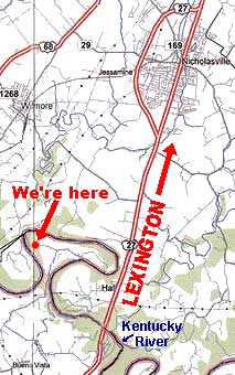
Also in the map at the right you can see how, coming from Lexington on US 27, a few miles after crossing the Kentucky River you'll take Kentucky Hwy. 1845 to the right. When that road comes to a T, with a red fire station exactly in front of you, go to the right instead of following the median stripe to the left. Now just stay on this road all the way to its end. When this road ends at a T, go to the left past the stone house and the trailer on the right. On the one-lane asphalt road continue around the bend to the road's end, where the two-story, white farmhouse will be impossible to miss. |
 In the second map above,
where Ray Wilson Road ends inside boot-shaped Polly's Bend, we are on the left (west), not
on the right as the star shows. The map at the right shows where we are.
In the second map above,
where Ray Wilson Road ends inside boot-shaped Polly's Bend, we are on the left (west), not
on the right as the star shows. The map at the right shows where we are.