September 20, 2015
YAXUNAH'S CENOTES
Visitors driving across the Yucatan sometimes get the notion that every little town has its cenote, or water-filled sinkhole. That's almost the truth, since cenotes are were people traditionally got their water, and therefore built their homes next to them. The Yucatan Peninsula has so many cenotes because geologically the region is a big slab of limestone honeycombed with caves, and cenotes form when caverns collapse.
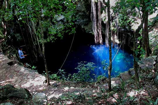
Many towns, like Yaxhunah, have made their cenote into tourist attractions. Yaxhunah's cenote has a fence around it and you pay a small entry fee. In exchange the sinkhole has easy access, is kept clean, and flotation vests are supplied to keep you afloat in deep water. The cenote's water is amazingly blue and at midday seems to glow with an internal light, as shown at https://www.backyardnature.net/n/15/150920cn.jpg.
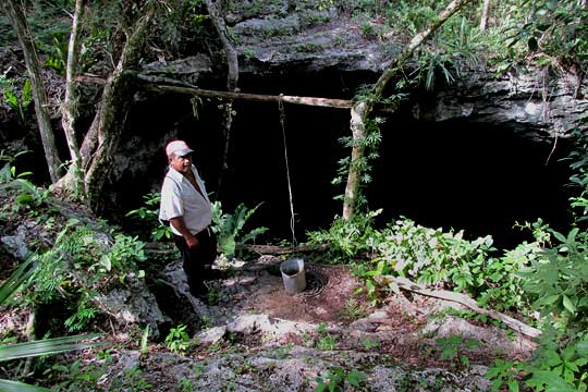
Other cenotes are scattered here and there throughout the area, and that might be one reason the ancient Maya concentrated in this area, leaving such interesting ruins. For example, not too far from the ruins there's the one shown at https://www.backyardnature.net/n/15/150920co.jpg.
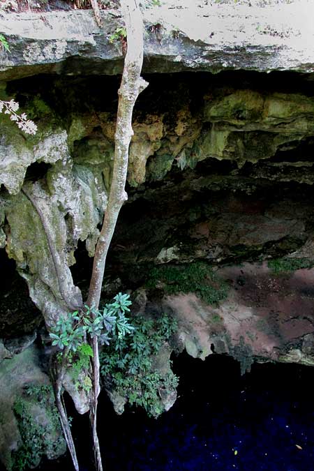
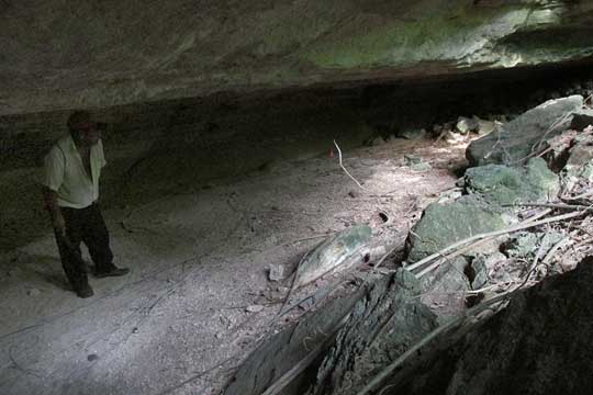
Few outsiders ever see this one. Nowadays only beekeepers take water from it during the dry season to water their hives. A peep over the ledge shows the usual interesting plants adapted to moist, shaded environments, stalactites forming along the wall, strangler fig stems dangling into the water, and a certain curious feature the locals can't avoid pointing out, You can see if you can find the curiosity at https://www.backyardnature.net/n/15/150920cp.jpg.
The strange feature is what looks like the silhouette of a short person, toward the picture's lower, right corner, the legs dangling from a rock ledge toward the blue water. It's just vegetation and an irregular rock formation, but in this land inhabited by gnome-like alux and where "bad winds" and the evil eye are daily concerns, many folks can't accept such a manifestation without wondering what it means.
The area has other cenotes as well, each one with its own history, character, and aura of speculation surrounding it.
*****
ALUX REJOLLADA
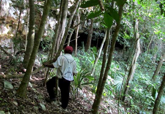
Don Francisco took me deep into the woods where even many of the locals haven't been, showing me what he can guide visitors to if eventually visitors start coming here wanting to explore and see such things.
One destination was a rejollada, (REH-ho-YAH-dah)" the name given to any extensive sinkhole containing no water. If it had water, it'd be a cenote. Cenotes result from the collapse of subterranean caverns, and probably most rejolladas do, too, though when they're particularly large and shallow, sometimes I wonder. This particular rejollada was about a hectare large (2.5 acres), and its floor was occupied with rocks, debris and big trees. Inside the depression the environment was less exposed to desiccating wind and sunlight than the higher forest surrounding us, and the soil seemed deeper and richer. Plants of moist, shaded environments, such as Chamaedorea palms, were more commonly seen. This special habitat may have been very important to the ancient Maya who built Yaxunah ruins.
For, the rejollada lies within half an hour walk of the ruins and rather close to the famous sacbé, or ancient, elevated road, connecting Yaxunah with Cobá (more about that below). Travis Stanton and others in their report Archaeological Investigations at Yaxuná, 1986-1996, published by the UK's Archaeopress in 2010, says that the ancient Maya are known to have cultivated cash crops, including cacao, in such rejolladas. He suggests that during Yaxunah's Formative Period the control of this rejollada by a particular family or group may have helped establish and maintain their elite position in the community.
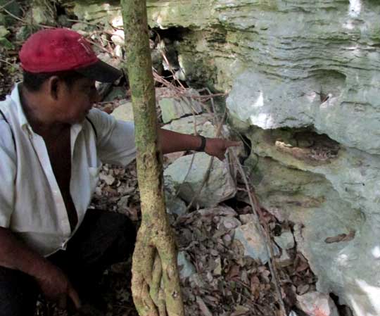
You can see Don Francisco inside the rejollada working his way toward an overhang, or rock house, in the depression's wall at https://www.backyardnature.net/n/15/150920re.jpg.
A view inside the overhang is at https://www.backyardnature.net/n/15/150920rf.jpg.
Here Don Francisco can show what appear to be ancient markings on the stone, and maybe even some color applied to the rocks. The Don, however, seems less impressed with how the ancient Maya may have used the rejollada than his own feelings about the depression's current status as a perfect home for alux, if alux exist (pronounced ah-LOOSH), for alux are the Mayas' gnomes or elves, never seen except in mysterious circumstances, but generally regarded as being around, as being important, and as needing to be paid attention to, and respected.
The Don showed me a special place on the rock face where hunters who come into the area leave offerings of pozol, the traditional drink made from masa, which is a moist paste made of ground hominy. It's understood that such offerings enhance your chance of an animal offering itself to you, though of course it's no guarantee. But it's pretty sure that if you don't offer pozol, you'll go home with an empty bag.
On the rejollada's rough wall Don Francisco showed me a special niche he always visits, where there's a collection of small bones and pottery found here and there, shown at https://www.backyardnature.net/n/15/150920rg.jpg.
One doesn't ask about the use of such features, not when it's supposed that this is exactly the kind of little gathering of curiosities alux might find agreeable, even though the presence of alux themselves is not being asserted outright. One just senses that if a mouse's femur is spotted, or an ochre-colored pottery fragment that maybe once was part of a pot an ancestor had in his home, it can't hurt to add such items to the little collection, maybe with a reverential nod and a respectful backing away.
******
THE SACBÉ BETWEEN YAXUNAH & COBÁ
The ancient Maya often constructed straight, elevated causeways within and between certain of their sites. The causeways were made mostly of stone and fill-dirt, and capped with a kind of soft, crumbly or even powdery, white limestone often found in the Yucatan, locally called sascáb. Sascáb is white, so the ancient causeways were white roads shooting through the green forest, and the Maya called them sacbé, which means
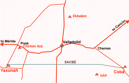
"white road." By far the longest sacbé in the Maya world is the one with one end at the ruins of Yaxunah and the other at the ruins of Cobá 100kms (62mi) to the east, as shown on the map at https://www.backyardnature.net/n/15/150920sa.gif.
According to Stephan Houston & Takeshi Inomata in The Classic Maya (Cambridge University Press, 2009), Yaxunah's causeway probably was constructed around the 600s. The first evidences of human occupation at Yaxunah are from about 450 BC, so Yaxunah had been around awhile before the sacbé was built. Academic maps show that the causeway is not perfectly straight. From Yaxunah it shoots eastward in a way that would carry it north of Cobá, but it bends southward before reaching there, as indicated in the above map.
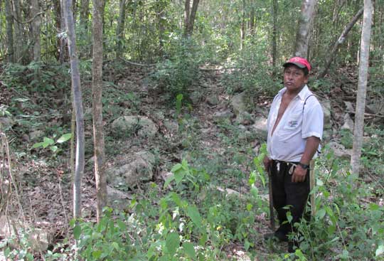
Today, in the forest east of Yaxunah, the sacbé is clearly visible as a slightly raised pile of rocks arranged in a straight line several meters across, the line extending straight for as far as can be determined. You see my friend Don Francisco standing where a forest trail crosses the structure at https://www.backyardnature.net/n/15/150920sa.jpg.
When guides take you to see the cenotes, rebajada and the sacbé, the trail passes over the causeway in several places and sometimes runs along its side, better giving an impression of what it might have been like. Right next to the ruins, however, it's missing. At one point people at Yaxunah feared attack from Cobá, so they ripped out their sacbé and put up defensive walls.
*****
CRYSTALS IN ANARCHY
This landscape of rampaging greenness, so few flowers or fruits but the greenness irrepressible, from day to day the lushness, the shagginess, the dark-green aggressiveness compounding, sprawling onto roadsides, viney tangles weighing down trees, gardens out of control... and I walk along the roads outside of town with the rainy-season sky overhead churning and boiling and through sweat-stung eyes one thing I see anchors my belief that all this isn't just pure herbaceous anarchy that eventually will suffocate and weed me out, and that thing is this:
That there's geometry among these roadside weeds; their lawlessness is more apparent than real; governing principles control their growth even now so I can trust that at least eventually things will resolve into order, that angles and planes, edges and points will respect traditional boundaries, and still there will be paths and open places, where one can think and escape.
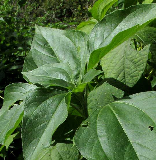
I can show you a little of what I'm talking about. For instance, there's this extremely fast-growing member of the Sunflower Family, the Sunflower Goldeneye, Viguiera dentata, which forms nearly pure stands right along the road, and right now is around chest high but later will thrust flowers well over our heads, and when you look at these weeds from the side, the way people walking along the road see them, they just make a visual clutter of stems and leaves, as shown in a close-up of the top of one at https://www.backyardnature.net/n/15/150920vr.jpg.
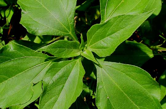
But, if you view it from above, the way the sun sees it, there's discipline. These Sunflower Goldeneyes shoot upward deploying their leaves spirally along rough stems, but the spiralings are controlled. The leaves align so that the smaller ones at the top shade the larger ones below the least possible. You see all this clearly if you take the sun's view, which is done at https://www.backyardnature.net/n/15/150920vq.jpg.
Sometimes as I walk along the roads' green walls I try to imagine it all without the inner restraint but, at least in all this heat and wetness and greenness, that's just too terrible to think about, and I lean over to see that sun-view, the geometry, the rationality behind it all.
Blessed be geometry in unforeseen places, and blessed be the mind that still can spot it and know its meaning.
*****
STILL NO INTERNET CONNECTION
Our Internet connection at Yaxunah still has failed to materialize, though people who seem like they should know keep predicting that it'll be established during the next two weeks
-- as they've said since July.
If this Newsletter is posted on time, it's because I've taken a taxi to Pisté to visit a ciber. If we don't get Internet soon I'll begin looking for a new place. I like it here but without the Internet I can't do the job the community expects me to do in exchange for hosting me here.
*****
FEATURED ESSAYS FROM THE PAST:
"Healthy Looking Folks at Wal-Mart" from the September 13, 2009 Newsletter, at https://www.backyardnature.net/n/p/090913.htm
"Learning to See" from the February 28, 2010 Newsletter, at https://www.backyardnature.net/n/p/100228.htm
*****
Best wishes to all Newsletter readers,
Jim
All previous Newsletters are archived at https://www.backyardnature.net/n/.