September 29, 2006
KENTUCKY COFFEE TREES
About an hour after my last Newsletter was issued, on Thursday, September 21, my nature-photographer friend Jerry arrived from Mississippi. It was a chilly, breezy, fallish day with an almost painfully blue, sunlight-filled sky so within an hour Ruth, Jerry and I were wandering atop nearby Kentucky River cliffs looking for access to the river below. We never did find a way down, though.
However, maybe that day it would have been a shame to descend into the valley, for, there upon the rounded, grassy hilltops the dazzling sunlight, the sharp wind and the grass's intense, emerald greenness against the deep blue sky was too grand to leave. Mississippi's summer has been droughty so Jerry was transfixed by our lushness and profound greenness, just as I'd been when I'd arrived in Kentucky from dry-season Yucatan five months ago.
In this area wherever the land is flat enough for a cow to stand up the forest has been cleared. The white, limestone cliffs, however, are forested, except where they're vertical or form overhangs. At the cliff-top forest edge I was surprised by the number of Kentucky Coffee Trees, GYMNOCLADUS DIOICUS. Coffee Trees, with their doubly compound, three-ft-long leaves almost look like Honeylocust trees, except that their trunks lack spines and their legumes are shorter and thicker. You can see leaf, fruits and more here.
Coffee trees, which are members of the Bean Family, have an unusual distribution. Basically they're found in the eastern US, except that they're absent from most coastal states and the entire Southeast, except for that region's northwest corner. Why would a tree found in Kentucky not also grow in Virginia or Alabama?
Another curious thing is that this species is found in two very dissimilar habitats. As we see, at Polly's Bend it inhabits fairly dry limestone cliffs, but in western Kentucky I've only found it in rich alluvial soil alongside rivers. I wouldn't be surprised if someday it's decided that two species are involved, species looking exactly alike, but being physiologically different.
Nowadays Kentucky Coffee Trees are little known and seldom encountered. However, I'll bet that someday they'll be planted extensively. That's because the tree's big leaves are issued later in the year than most other trees', and fall off earlier in autumn, plus once leaves have fallen the tree's relatively scanty branching casts a limited shadow. In other words, the tree is perfect for solar homes needing tree shadows only during the season's hottest months.
The tree got its name from early North American colonists who roasted and ground the large seeds as a coffee substitute. The roasting neutralizes poisons in the raw seeds. Woodworkers sometimes use the heavy, strong wood in cabinetwork, for fence posts, and in construction.
*****
ROCKS ACROSS KENTUCKY
After that gorgeous day along the Kentucky River cliffs for two days we had more rain than I've seen in years. All my pots left outside filled up long before the rain stopped so I never got a measure of how much had fallen. Several deaths resulted from the flooding. Finally on Sunday the rain ended and Jerry and I left Polly's Bend.
What a fine day it was for admiring road cuts! First we headed south, the Bluegrass Region's hard, white, Ordovician-age limestone soon yielding to soft, crumbly, black shale as we coursed through the Eden Shale Belt, of younger Ordovician age. Jerry asked what fossils might be found in the shale. I said that only forms of sea life would be found, for Ordovician life was so ancient (490 to 443 million years old) that species hadn't yet evolved capable of living on land. Land life wouldn't appear until the next geological period, the Silurian.
The area of shale outcropping got rougher and rougher as alone-standing, round-topped hills began appearing. We were entering The Knobbs Region, a narrow belt of country encircling the Bluegrass Region, which is round like a bull's-eye.
Then we turned due west and for a long time traversed the Mississippian Plateau Region. It's called a plateau for strictly geology-structure reasons. Just looking at it, there's nothing plateau-like about it. It's a fairly flat land composed of outcropping limestone of Mississippian-period age (354 to 323 million years old). Soil deriving from this limestone is often rusty-red because of its iron content, and the landscape is pitted with lots of sinkholes. The limestone is honeycombed with interconnecting caves, so when a cave near the surface collapses a sinkhole results. A sinkhole is just a large hole in the ground, sometimes holding water. In the Yucatan we call them cenotes. Around noon we passed just south of Mammoth Cave National Park, where visitors can enter the world's largest mapped cave system.
In late afternoon the Mississippian Plateau's flattish, often unforested plain began breaking into wooded hills again. We were approaching the day's final destination, western Kentucky's Land Between the Lakes National Recreation Area.
*****
LAND BETWEEN THE LAKES
Land Between the Lakes is a 260-sq-mile peninsula jutting northward into Kentucky from Tennessee. It's separated from surrounding land by two large Tennessee-Valley-Authority lakes: Lake Barkley on the eastern side, Kentucky Lake on the western. You can see maps showing the area's configuration and read about the region's attractions and recreation offerings at http://www.explorekentuckylake.com/lbl/.
At the Visitor Center we acquired backcountry camping permits ($5 apiece) and headed for a lake. That night my tent stood right at the lake's edge, and what a sleep I had accompanied by the sounds of lapping water and chirping crickets.
Among the pebbles and gravel at the water's edge were many mussel shells, some of them six or seven inches across. Using an identification chart for Mississippi's mussels, for which Jerry himself had provided the fine pictures, Jerry said it looked to him as if the mussels were Tennessee Pigtoes, FUSCONAIA BARNESIANA, and Muckets, ACTINONAIAS LIGAMENTINA. To me the many species' shells looked so similar that I couldn't decide.
I was happy to see mussels still surviving in the wild. When I was a kid every ditch and pond in our area had mussels in them, sometimes more than one species and present in abundance. Then came heavy agricultural use of pesticides and Corps-of-Engineer stream-channelization, and now you hardly ever see any.
The next day we visited LBL's "Elk and Bison Prairie." This was an enclosed 700-acre restoration of a natural prairie on which herds of Elk and Bison had been established. As in the movie Jurassic Park, you drive your car into the enclosure and use it as an observation blind.
First we came upon some Elk, also called Wapiti, CERVUS CANADENSIS. There was a herd of five or six females and one male, the male bearing a big pair of six-pointed antlers. He was working hard to face down other males who sometimes wandered by his harem, giving side-glances. Often he'd raise his head, pull up his upper lip and show his front teeth as he moved toward a female's rear end (the "Flehmen Expression" I wrote about in the June 20, 2004 Newsletter). He was smelling her pheromones and he seemed to like them. Regularly he "bugled," making a high-pitched, melodious whistle-call sounding a little like the noise I used to make as a kid blowing into a garden hose. Later that night when Jerry and I were camped miles away we heard the call and were amazed it could carry for such a long distance.
I wondered what the main difference was between deer and elk. Both are members of the Deer Family, the Cervidae. Certainly one big difference is in size. An average deer might weigh 150 pounds, while elk get up to 800 pounds, even 1000 for old males.
Then we drove on and came upon a herd of about a dozen Bison, or Buffalo, BISON BISON. For a while we were slowly driving down the middle of the road with Bison walking on both sides of us. We could have reached out and patted them if we'd wanted. Though they were majestic while grazing peacefully in tall grass, up close they were huge, black, fly-covered, grungy, scarred and scabby. Most had bloody sores on their flanks where they'd scratched themselves with their horns, probably trying to shoo biting flies.
Ruth at Polly's Bend always says there's nothing like the feeling of being among horses, just standing with them and having their big bodies next to yours. I never felt that sensation very intensely, but as we moved down the road with Bison all around us, their muscles rippling beneath black fur, the odors of their foamy, grassy breaths gushing through the open windows, the pounding of their hooves on the ground... I knew exactly what Ruth had felt.
Both Elk and Bison at one time roamed naturally in Kentucky, though they were exterminated here long ago by overhunting. Similarly, at one time Kentucky was home to extensive prairies. Early reports by European explorers mention finding prairies with grass "as high as the head of a man on horseback." Mostly the prairies were limited to the Mississippian Plateau region with its underground drainage, and extreme western Kentucky, with its unconsolidated, Coastal Plain geology. It's assumed the grasslands were largely maintained by frequent burnings by Native Americans, who may have intentionally encouraged Bison populations by maintaining open, grassy areas. Otherwise, there was certainly enough annual rainfall in this area to support forests.
At http://www.kentuckylake.com/lbl/elkprairie.htm you can click on the picture to see more images of Bison at LBL's Elk and Bison Prairie.
*****
WICKLIFFE MOUNDS
After our first night of camping at LBL we continued on westward to the town of Wickliffe, Kentucky. It's on the Mississippi River just south of where the Ohio River joins the Mississippi, the Ohio actually being the larger river at this point. Jerry wanted to photograph a few things here. On Wickliffe's northern edge we pulled into Wickliffe Mounds State Historic Park, the official site of which can be visited at http://www.state.ky.us/agencies/parks//statehistoricsites/wm/index.htm.
At Wickliffe impressive archeological remains have been found of a village of Native Americans known as Mississippian Mound Builders. The village was occupied from about AD 1100 to 1350. People there farmed the nearby river bottoms and participated in a vast trade network. You can see photos of artifacts at http://users.stlcc.edu/mfuller/Wickliffe.html.
Inside a large building you can view examples of a burial. However, the skeleton lying there is plastic, since the bones actually found at the site have been stored elsewhere, it being considered disrespectful to Native Americans to be exposing bones of their ancestors to public display for an admission fee.
*****
COLUMBUS-BELMONT STATE PARK
Next we headed south along the Mississippi River to Columbus-Belmont State Park, at the edge of the tiny town of Columbus. The park's official page resides at http://www.stateparks.com/columbusbelmont.html.
At the Civil War's beginning, Columbus, Kentucky's location was regarded as being of profound strategic importance because the Mississippi River ran right below its high, loess-mantled cliffs. Whoever controlled those heights controlled the Mississippi.
First the Confederates took charge. They came up with the idea of stretching an enormous chain across the river to Belmont, Missouri, to keep Yankee boats from passing downstream. Jerry photographed a segment of the big chain, and fortifications of the kind the Confederates had thrown up atop the hills.
Ultimately action elsewhere made the South's defense of Columbus impossible so the Confederates withdrew without a fight, Columbus and its strategic cliffs were taken over by the North, and Columbus remained under Union control for the rest of the war.
*****
REELFOOT LAKE AND BEYOND
Continuing southward, Reelfoot Lake just across the state line in Tennessee came next. From the highway all you see is a large lake that's obviously very shallow because here and there big, lone Baldcypress trees emerge from the water. The shore is over- developed with marinas, boat launches, private homes and the like.
I've always heard that Reelfoot was formed during the big earthquakes of 1811 and 1812, "when the Mississippi River ran backwards and land around Reelfoot slumped and filled up with water." However, a Wikipedia article mentions the possibility that the lake was formed during the Ice Age. The Wikipedia article is at http://en.wikipedia.org/wiki/Reelfoot_Lake.
Reelfoot Lake is the winter home to enormous flocks of overwintering waterbirds, Bald Eagles and other worthy birds.
From Reelfoot we kept traveling southward, making our next major stop the Meeman-Shelby Forest State Park on the northern edge of Memphis. It's a 13,467-acre park with two pretty lakes, more than 20 miles of hiking trails, and a fine bottomland forest extending right up to the Mississippi River. We were most interested in the park's high cliff's facing the river. They were capped with Ice Age loess, as explained at my site at https://www.backyardnature.net/loess/.
During spring wildflower season this must be a wonderful spot, and Memphis is lucky to have such a wild, natural area so close to it.
Then from Memphis we made a bee-line to Jackson, Mississippi. The next day my Natchez friend Karen and her mom picked me up and took me to my old trailer, which is parked next to the woods down below Karen's house.
*****
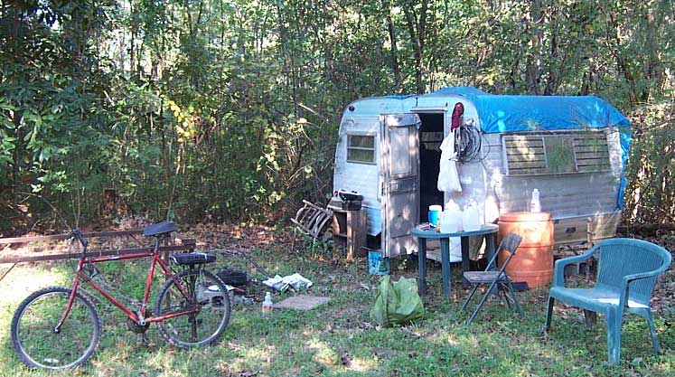
MY LITTLE TRAILER
Those of you who have been with me since my earliest newsletter-writing days at Laurel Hill Plantation will recall that I used to live a hermit's life in the woods a few miles south of Natchez -- about 15 miles southwest of where I am now. I lived in an old hangdog trailer and had phone and electrical wires strung through the woods so I could have Internet service. A picture from those days, with me preparing breakfast, is at https://www.backyardnature.net/j/jimslife.htm.
Later I moved the trailer to the Sandy Creek location, and when I left there I stored it at the home of my friends Jackie and Karen, in a wooded area near Natchez. Though the poor old trailer made it through Hurricane Katrina and lots of fallen tree limbs, it is gradually coming apart and everything in it is succumbing to Mississippi mildew. About once a year I pass through this area and sleep in my old friend. You can see what it looks like now at https://www.backyardnature.net/n/06/060929.jpg.
After traveling for three days across small-town, middle-class, heartland America, I have seen too much of this:
Therefore, right now I'm feeling pretty good about my little trailer. My trailer doesn't need mowing around it, doesn't need a new $1000 door or fancy curtains, or a wall-hanging, flat-screen TV. It's just sitting there as capable as ever of keeping rain off my head and the mosquitoes out. Cricket chimes and birdcalls float through its screen windows as they always did, and I sleep in it as soundly now as I did on my first night in it years ago in the woods.
*****
Best wishes to all Newsletter subscribers,
Jim