On a Sunday afternoon I visit the nature reserve on the slope above Yerba Buena. Crossing the main highway I pass by large, impressive signs bearing maps of hiking trails, brief remarks about the various life-zones of plants and animals to be found in the reserve, and invitations to park and enjoy "your forest." A while back the Instituto de Historia Natural in Tuxtla took over administration of this land, though it still belongs to Yerba Buena.
To reach the reserve's upper elevations where the most interesting plants and animals are found a fairly steep slope must be climbed. As I begin my ascent up the zigzagging trail, I'm astonished to find that a barbed-wire fence has been erected running straight up and down the slope, cutting across every zig and zag in the path. Each time you zig or zag, about twenty feet up the path you have to cross the fence.
This fence is the invaders' doings. Yerba Buena's water supply comes from the cloud forest above, and the pipes carrying the water are laid beneath the soil over which the zigzagging trail climbs. The invaders have placed their fence so that the water pipes are just inside "their" land.
Eventually I reach a large field halfway up the slope. Once Yerba Buena cultivated a garden here, but now on the big roadside maps this field is designated as a "Zone of Reforestation." Nevertheless, today I find five horses of invaders who have ridden in from Pueblo Nuevo to work on their claims. I approach one plot of black beans planted about a month ago. I speak politely to the two men standing there looking at me. They glare at me coldly and show little interest in talking.
Farther upslope I find a man clearing weeds with his machete. When he sees me his eyes open wide. He walks up to me and without my asking a single question loudly gives me his whole name and his address, tells me how to find his house in Pueblo Nuevo, and informs me who his brothers are, who also claim land here. Then he launches into a long description of his plans to put a field of beans here, and later to grow corn.
Obviously the man is challenging me. "If you people at Yerba Buena want to try to get us off this land," his demeanor is saying, "then you just try it. We're resolved to fight... "
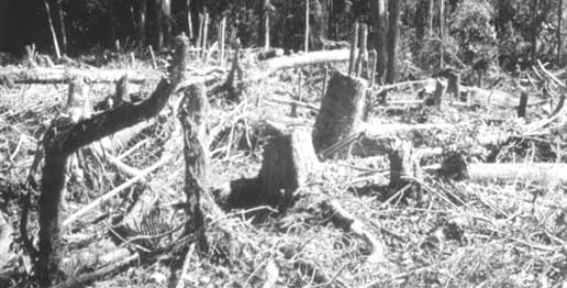
I continue climbing into the cloud forest, find a limestone rock and sit on it. At this elevation the valley toward the southwest spreads out like a view from an airplane window. Some of highest, farthermost peaks must constitute the Continental Divide a hundred miles away. In several places thick clouds of white smoke rise where Indians burn off slopes, preparing to plant corn and beans. This is slash-and-burn agriculture, exactly as the tropical-ecology books describe it. Burn off an area, plant crops for two or three years, until the weeds and insects get too bad, then simply shift to another part of the slope, hack the trees down and burn, and start the cycle over again.
Only small patches of forest remain in the landscape before me. "Patches" is a good word, because from here the land looks poor and patched-up, like a Kentucky mountaineer's patchwork quilt that after many years of use now is thin, faded and about to fall apart.
This reserve in which I sit is one of the very few semi-unspoiled spots left in this entire mountain range. Clearly, however, it will not be here for long, despite the best intentions of those who should have the wherewithal to protect it, but do not.